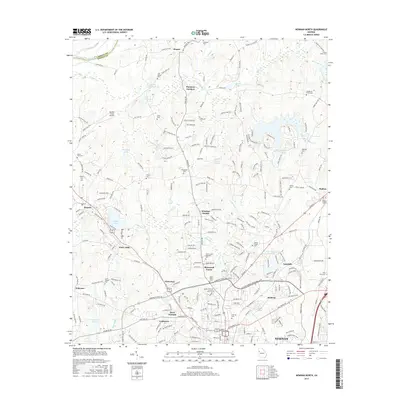
2017 Map of Newnan North
USGS Topo · Published 2017About this map
The Chattahoochee River defines the northern boundary of this Coweta County landscape, where the rural character of the Georgia Piedmont meets the expanding residential footprint of Newnan. This 2017 study illustrates the intersection of mid-century infrastructure and older agrarian roots, visible in the numerous family cemeteries such as Andrews Cem and George W Smith Cem. Local industrial history is rooted in settlements like Sargent and Arno Mills, while leisure and public spaces are represented by Dunaway Gardens and the Panther Creek Airport. The terrain is deeply etched by a network of waterways including Wahoo Cr and Little Wahoo Cr, which historically powered local industry at sites like Sewell Millpond. The map captures the suburbanization of the area through neighborhoods like Sherwood Forest and Windsor Estates, which have developed alongside long-standing rural junctions like Roscoe and Welcome.
Find a feature on this map
250 named features on this map. Tap any name to fly to it.
Don’t see what you’re looking for? This feature index may not catch every label — zoom into the map to look around manually.
Map Details
Editions of this 2017 Newnan North Map
This is the sole edition of this map. No revisions or reprints were ever made.
Other maps of this area

1891 · Marietta
USGS Topo · 1:125,000

1895 · Marietta
USGS Topo · 1:125,000

1897 · Marietta
USGS Topo · 1:125,000

1901 · Marietta
USGS Topo · 1:125,000

1953 · Atlanta
USGS Topo · 1:250,000

1954 · Palmetto
USGS Topo · 1:24,000

1957 · Atlanta
USGS Topo · 1:250,000

1958 · Rico
USGS Topo · 1:24,000

1958 · Atlanta
USGS Topo · 1:250,000
1958 · Villa Rica
USGS Topo · 1:62,500