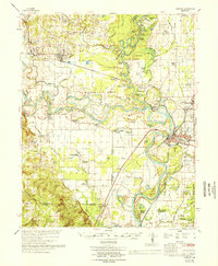
1966 Map of Newport
USGS Topo · Published 1966About this map
The White River defines the landscape of Jackson and Independence counties, its serpentine course carving deep bends like Caster Bend and Hinkle Bend. This 1960s-era geography reveals a region deeply tied to its water and rail lines, where the Missouri Pacific railroad serves established towns like Newport and Diaz. The presence of numerous oxbow lakes and brakes, such as Donahue Brake and Bell Lake Brake, underscores the alluvial nature of the territory.
Find a feature on this map
123 named features on this map. Tap any name to fly to it.
Don’t see what you’re looking for? This feature index may not catch every label — zoom into the map to look around manually.
Map Details
Editions of this 1966 Newport Map
This is the sole edition of this map. No revisions or reprints were ever made.
Other maps of this area

1890 · Batesville
USGS Topo · 1:125,000

1891 · Batesville
USGS Topo · 1:125,000

1932 · Strawberry
USGS Topo · 1:62,500

1935 · Alicia
USGS Topo · 1:62,500

1935 · Strawberry
USGS Topo · 1:62,500

1935 · Newport
USGS Topo · 1:62,500

1935 · Augusta
USGS Topo · 1:62,500

1935 · Tuckerman
USGS Topo · 1:62,500

1935 · Bald Knob
USGS Topo · 1:62,500

1940 · Tilton
USGS Topo · 1:62,500