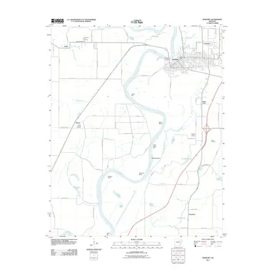
2011 Map of Newport
USGS Topo · Published 2011About this map
The White River carves a deep, winding path through the heart of this Arkansas landscape, defining the boundaries of local life and industry. In the town of Newport, a concentrated street grid fans out from the Newport Bridge, anchored by the Newport Post Office. This river-centric geography is marked by numerous sandbars and bends, including Reese Bar, Hinkle Bend, and Stalcup Bend, which illustrate the dynamic nature of the waterway.
Find a feature on this map
78 named features on this map. Tap any name to fly to it.
Don’t see what you’re looking for? This feature index may not catch every label — zoom into the map to look around manually.
Map Details
Editions of this 2011 Newport Map
This is the sole edition of this map. No revisions or reprints were ever made.
Other maps of this area

1935 · Newport
USGS Topo · 1:62,500

1935 · Augusta
USGS Topo · 1:62,500

1935 · Tuckerman
USGS Topo · 1:62,500

1940 · Tilton
USGS Topo · 1:62,500

1953 · Memphis
USGS Topo · 1:250,000

1956 · Memphis
USGS Topo · 1:250,000

1956 · Tilton
USGS Topo · 1:62,500
1956 · Newark
USGS Topo · 1:24,000

1957 · Augusta
USGS Topo · 1:62,500

1962 · Jacksonport
USGS Topo · 1:24,000