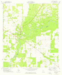
1974 Map of Newton
USGS Topo · Published 1976About this map
The Newton town site serves as the focal point of this mid-1970s study, situated along a prominent bend in the Flint River. This area of Baker County shows a distinct rural landscape where the river and its tributaries, such as Cooleewahee Creek, dictate the movement of roads and the placement of community landmarks. Education and faith are central to the local geography, evidenced by the County High Sch in town and scattered country churches like White Corner Ch, Mt Airy Ch, and Zion Grove Ch.
Find a feature on this map
20 named features on this map. Tap any name to fly to it.
Don’t see what you’re looking for? This feature index may not catch every label — zoom into the map to look around manually.
Map Details
Editions of this 1974 Newton Map
2 editions found
Other maps of this area

1953 · Dothan
USGS Topo · 1:250,000

1954 · Dothan
USGS Topo · 1:250,000

1955 · Dothan
USGS Topo · 1:250,000

1956 · Baconton
USGS Topo · 1:62,500

1956 · Newton
USGS Topo · 1:62,500

1971 · Camilla
USGS Topo · 1:24,000

1971 · Hopeful
USGS Topo · 1:24,000
1971 · Branchville
USGS Topo · 1:24,000
1974 · Baconton South
USGS Topo · 1:24,000

1974 · Elmodel
USGS Topo · 1:24,000