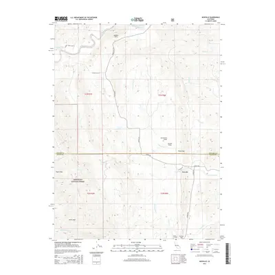
2015 Map of Newville
USGS Topo · Published 2015About this map
Newville sits at the edge of the Sacramento Valley and the Central Valley floor, marking a point where the open plains meet the rising foothills of the Mendocino National Forest. This 2015 survey illustrates the rural boundary between Tehama and Glenn counties, characterized by a complex network of seasonal drainages including Thomes Cr, N Fork Stony Cr, and Salt Cr. The landscape is defined by its prominent ridgelines such as Rocky Ridge, Digger Ridge, and Heifer Ridge, which guide the path of local corridors like Newville Rd and Co Road 306. Genealogists and local historians can locate the Millsap Cemetery near Burrows Gap, while the northern portion of the map is dominated by the elevation of Williams Butte. The survey reflects a sparsely populated ranching and forest-fringe economy, where the terrain dictate the layout of the road network and water rights.
Find a feature on this map
31 named features on this map. Tap any name to fly to it.
Don’t see what you’re looking for? This feature index may not catch every label — zoom into the map to look around manually.
Map Details
Editions of this 2015 Newville Map
This is the sole edition of this map. No revisions or reprints were ever made.
Other maps of this area

1919 · Fruto
USGS Topo · 1:62,500

1919 · Elk Creek
USGS Topo · 1:62,500

1944 · Fruto
USGS Topo · 1:62,500

1944 · Flournoy
USGS Topo · 1:62,500

1948 · Elk Creek
USGS Topo · 1:62,500

1952 · Paskenta
USGS Topo · 1:62,500

1957 · Elk Creek
USGS Topo · 1:62,500

1957 · Ukiah
USGS Topo · 1:250,000
1958 · Fruto
USGS Topo · 1:62,500
1958 · Flournoy
USGS Topo · 1:62,500