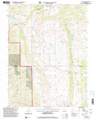
1995 Map of Newville
USGS Topo · Published 2001About this map
Newville and Paskenta anchor this corner of the California Coast Range during the mid-1990s, where the landscape is defined by the dramatic meeting of valley ranchlands and the Mendocino National Forest. The map detail follows the transition from the flatlands around Thomes Creek to the sharp elevation gains of Rocky Ridge and Heifer Ridge. Local genealogy is preserved in markers such as Millsap Cem and a cemetery near the north border, while the presence of the Airstrip and Newville Road suggests the era's reliance on rural transport networks. Notable landmarks like Williams Butte and Walcott stand above a terrain carved by numerous seasonal waterways including Salt Creek and the North Fork Stony Creek. The boundary between Tehama and Glenn counties cuts directly through the settlement of Newville, illustrating how political lines often bisect historical community centers in this region.
Find a feature on this map
30 named features on this map. Tap any name to fly to it.
Don’t see what you’re looking for? This feature index may not catch every label — zoom into the map to look around manually.
Map Details
Editions of this 1995 Newville Map
This is the sole edition of this map. No revisions or reprints were ever made.
Other maps of this area

1919 · Fruto
USGS Topo · 1:62,500

1919 · Elk Creek
USGS Topo · 1:62,500

1944 · Fruto
USGS Topo · 1:62,500

1944 · Flournoy
USGS Topo · 1:62,500

1948 · Elk Creek
USGS Topo · 1:62,500

1952 · Paskenta
USGS Topo · 1:62,500

1957 · Elk Creek
USGS Topo · 1:62,500

1957 · Ukiah
USGS Topo · 1:250,000
1958 · Fruto
USGS Topo · 1:62,500
1958 · Flournoy
USGS Topo · 1:62,500