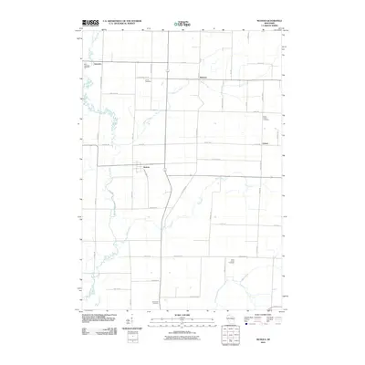
2010 Map of Nichols
USGS Topo · Published 2010About this map
Nichols sits at the center of this rural landscape, which is defined by the winding course of the Shioc River and its various tributaries. This 2010 survey shows a well-established grid of farm roads and small settlements like Briarton, Navarino, and Cicero scattered across Outagamie County. The drainage patterns of Toad Creek, Herman Creek, and Black Creek dictate much of the land use, interspersed with several prominent cemeteries that serve as focal points for local genealogy, including Saint Lawrence Cemetery and the Union Cemetery.
Find a feature on this map
45 named features on this map. Tap any name to fly to it.
Don’t see what you’re looking for? This feature index may not catch every label — zoom into the map to look around manually.
Map Details
Editions of this 2010 Nichols Map
This is the sole edition of this map. No revisions or reprints were ever made.
Other maps of this area

1955 · Embarrass
USGS Topo · 1:48,000

1955 · Appleton
USGS Topo · 1:62,500

1955 · Seymour
USGS Topo · 1:62,500

1955 · Green Bay
USGS Topo · 1:250,000

1956 · New London
USGS Topo · 1:48,000

1969 · Leeman
USGS Topo · 1:24,000

1969 · Lunds
USGS Topo · 1:24,000
1969 · Shiocton
USGS Topo · 1:24,000

1974 · Seymour
USGS Topo · 1:24,000

1974 · Zachow
USGS Topo · 1:24,000