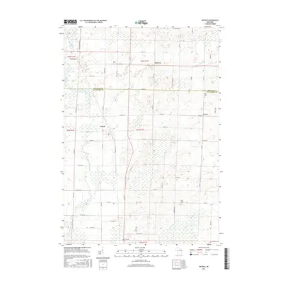
2016 Map of Nichols
USGS Topo · Published 2016About this map
Nichols and Cicero anchor this rural landscape along the Shawano Co Outagamie Co line. The terrain is defined by a dense network of watercourses including the Shioc River, Toad Cr, and Herman Cr, which create a complex environment of wetlands and small drainages typical of the region. This 2016 survey provides a clear view of the agricultural and small-town structure of Outagamie County, highlighting long-standing community centers like Briarton and Navarino. For genealogists and local historians, the map is particularly valuable for its documentation of cemetery sites dispersed across the townships. These include Union Cem near the northern boundary, North Cicero Cem and South Cicero Cem situated along the eastern corridor, and Emmanuel Cem to the south. The road network, including Old Hwy 47 and Co Rd VV, illustrates how these rural settlements remained connected by their original transport arteries into the 21st century.
Find a feature on this map
61 named features on this map. Tap any name to fly to it.
Don’t see what you’re looking for? This feature index may not catch every label — zoom into the map to look around manually.
Map Details
Editions of this 2016 Nichols Map
This is the sole edition of this map. No revisions or reprints were ever made.
Other maps of this area

1955 · Embarrass
USGS Topo · 1:48,000

1955 · Appleton
USGS Topo · 1:62,500

1955 · Seymour
USGS Topo · 1:62,500

1955 · Green Bay
USGS Topo · 1:250,000

1956 · New London
USGS Topo · 1:48,000

1969 · Leeman
USGS Topo · 1:24,000

1969 · Lunds
USGS Topo · 1:24,000
1969 · Shiocton
USGS Topo · 1:24,000

1974 · Seymour
USGS Topo · 1:24,000

1974 · Zachow
USGS Topo · 1:24,000