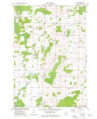
1974 Map of Nichols
USGS Topo · Published 1977About this map
The Shioc River and its tributaries, Toad Creek and Herman Creek, carve through the agricultural landscape of Outagamie and Shawano Counties in this mid-1970s survey. The village of Nichols serves as a central hub, where the Soo Line railroad intersects with a grid of rural roads like Muellaman Road and Scott Road. This period shows a community deeply rooted in its local institutions, evidenced by the clustered presence of Emmanuel Ch, St Johns Ch, and the United Brethren Ch. To the northwest, the Navarino State Wildlife Area provides a distinct transition from the cultivated fields of Lessor and Maine townships. Genealogists will find significant value in the documentation of local burial grounds, including Union Cem, North Cicero Cem, and South Cicero Cem, which anchor the surrounding farmsteads.
Find a feature on this map
41 named features on this map. Tap any name to fly to it.
Don’t see what you’re looking for? This feature index may not catch every label — zoom into the map to look around manually.
Map Details
Editions of this 1974 Nichols Map
This is the sole edition of this map. No revisions or reprints were ever made.
Other maps of this area

1955 · Embarrass
USGS Topo · 1:48,000

1955 · Appleton
USGS Topo · 1:62,500

1955 · Seymour
USGS Topo · 1:62,500

1955 · Green Bay
USGS Topo · 1:250,000

1956 · New London
USGS Topo · 1:48,000

1969 · Leeman
USGS Topo · 1:24,000

1969 · Lunds
USGS Topo · 1:24,000
1969 · Shiocton
USGS Topo · 1:24,000

1974 · Seymour
USGS Topo · 1:24,000

1974 · Zachow
USGS Topo · 1:24,000