
1914 Map of Nicholson
USGS Topo · Published 1957About this map
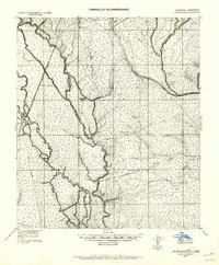
The Louisiana Mississippi Boundary Line snakes through a complex network of bayous and river channels in this 1914 tactical survey. Defined by the winding course of the Pearl River, the landscape is dominated by the sprawling Honey Island and its surrounding wetlands. Civil infrastructure is sparse but strategic, concentrated around the New Orleans Northeastern RR and various timber operations. The map documents the extensive presence of H Weston Lumber Co, with rail spurs and roads like 3 Notch Road and Carver Road penetrating the swampy interior to reach settlements like Logtown and Gainsville. The transition from the dense, water-logged western basins to the slightly higher ground near Westonia and the Jordan River reveals an era when river-based transit and lumber extraction were the primary drivers of settlement in the region.
Find a feature on this map
28 named features on this map. Tap any name to fly to it.
Don’t see what you’re looking for? This feature index may not catch every label — zoom into the map to look around manually.
Map Details
Editions of this 1914 Nicholson Map
2 editions found
Other maps of this area

1892 · Chef Menteur
USGS Topo · 1:62,500

1893 · Rigolets
USGS Topo · 1:62,500

1893 · Toulme
USGS Topo · 1:62,500

1921 · Nicholson
USGS Topo · 1:62,500

1935 · Slidell
USGS Topo · 1:62,500

1935 · English Lookout
USGS Topo · 1:31,680

1935 · Grand Island Pass
USGS Topo · 1:31,680

1936 · North Shore
USGS Topo · 1:31,680

1936 · Chef Menteur
USGS Topo · 1:62,500

1936 · Rigolets
USGS Topo · 1:62,500