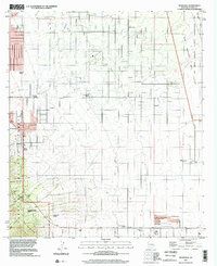
1996 Map of Nicksville
USGS Topo · Published 2002About this map
The Huachuca Mountains dominate the southwestern corner of this survey, where the Coronado National Forest meets a landscape defined by cattle ranching and modern desert settlement. The terrain transitions from steep canyons like Miller Canyon and Stump Canyon into a systematic grid of ranch properties and rural homesteads. This map documents a distinct concentration of named family-held lands, including the Wintergreen Mink Ranch, Smiling Tiger Ranch, and Kinjoekity Ranch, illustrating the private land-use patterns typical of this portion of Cochise County.
Find a feature on this map
27 named features on this map. Tap any name to fly to it.
Don’t see what you’re looking for? This feature index may not catch every label — zoom into the map to look around manually.
Map Details
Editions of this 1996 Nicksville Map
This is the sole edition of this map. No revisions or reprints were ever made.
Other maps of this area

1914 · Hereford
USGS Topo · 1:125,000

1915 · Benson
USGS Topo · 1:125,000

1922 · Sunnyside
USGS Topo · 1:62,500

1932 · Stark
USGS Topo · 1:62,500

1932 · Fairbank
USGS Topo · 1:62,500

1938 · Huachuca
USGS Topo · 1:62,500

1938 · Sunnyside
USGS Topo · 1:62,500

1943 · Benson
USGS Topo · 1:125,000

1948 · Miller Peak
USGS Topo · 1:24,000

1948 · Sunnyside SE
USGS Topo · 1:24,000