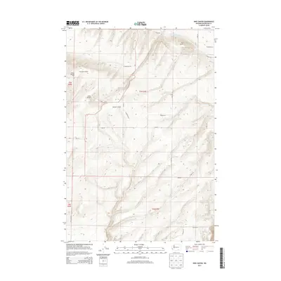
2013 Map of Nine Canyon
USGS Topo · Published 2013About this map
Horse Heaven Hills dominate this portion of Benton County, where the high basalt plateau is deeply dissected by drainage systems like Nine Canyon and Fourmile Canyon. The 2013 landscape reflects a mix of traditional dryland agriculture and modern infrastructure, indicated by the network of rural roads such as S Nine Canyon Rd and Les Blair Rd that follow the winding canyon floors and ridgelines. In the northeast, the Division Four Canal skirts around The Butte, illustrating the critical role of water management in this arid region of Washington. The topographic relief captured here shows the sharp transition from the elevated plains of the hills down into the distinct troughs of Switzler Canyon, providing a clear record of the area's geological and developmental layout in the early 21st century.
Find a feature on this map
26 named features on this map. Tap any name to fly to it.
Don’t see what you’re looking for? This feature index may not catch every label — zoom into the map to look around manually.
Map Details
Editions of this 2013 Nine Canyon Map
This is the sole edition of this map. No revisions or reprints were ever made.
Other maps of this area

1908 · Umatilla
USGS Topo · 1:125,000

1915 · Wallulah
USGS Topo · 1:96,000

1917 · Pasco
USGS Topo · 1:125,000

1918 · Wallula
USGS Topo · 1:125,000

1935 · Pendleton
USGS Topo · 1:125,000

1953 · Pendleton
USGS Topo · 1:250,000

1953 · Walla Walla
USGS Topo · 1:250,000

1956 · Pendleton
USGS Topo · 1:250,000

1958 · Walla Walla
USGS Topo · 1:250,000

1962 · Hat Rock
USGS Topo · 1:24,000