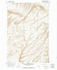
1964 Map of Nine Canyon
USGS Topo · Published 1966About this map
Nine Canyon and Switzler Canyon dominate this part of Benton County, carving deep drainage patterns through the upland terrain south of the Columbia River. The map, based on 1959 aerial photography and field-checked in the mid-1960s, reveals a landscape defined by agricultural infrastructure and early transport networks. A series of irrigation features, including a Canal and multiple Siphons, supports the dryland farming indicated by the presence of a Storage Bin. This network of water management was essential for local production in this arid climate.
Find a feature on this map
19 named features on this map. Tap any name to fly to it.
Don’t see what you’re looking for? This feature index may not catch every label — zoom into the map to look around manually.
Map Details
Editions of this 1964 Nine Canyon Map
This is the sole edition of this map. No revisions or reprints were ever made.
Other maps of this area

1908 · Umatilla
USGS Topo · 1:125,000

1915 · Wallulah
USGS Topo · 1:96,000

1917 · Pasco
USGS Topo · 1:125,000

1918 · Wallula
USGS Topo · 1:125,000

1935 · Pendleton
USGS Topo · 1:125,000

1953 · Pendleton
USGS Topo · 1:250,000

1953 · Walla Walla
USGS Topo · 1:250,000

1956 · Pendleton
USGS Topo · 1:250,000

1958 · Walla Walla
USGS Topo · 1:250,000

1962 · Hat Rock
USGS Topo · 1:24,000