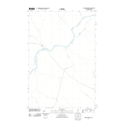
2011 Map of Ninemile Bridge
USGS Topo · Published 2011About this map
The Saint John River serves as the dominant geographical feature of this remote Aroostook County landscape, winding through a region primarily defined by its hydrology and timber-related infrastructure. The small settlement at Ninemile Bridge represents a rare point of human intersection in the deep north woods, situated where Realty Rd crosses the river. This crossing and the junction with Thibodeau Rd illustrate the essential transportation network used by the Maine logging industry. Numerous tributaries feed into the main river, including the family-named Billy Jack Brook and Ed Jones Pond, alongside consistently named watercourses like Sixmile Brook and Ninemile Brook. The map depicts a wilderness area where life and commerce are dictated by the flow of water and the accessibility of gravel haul roads through the dense interior.
Find a feature on this map
12 named features on this map. Tap any name to fly to it.
Don’t see what you’re looking for? This feature index may not catch every label — zoom into the map to look around manually.
Map Details
Editions of this 2011 Ninemile Bridge Map
This is the sole edition of this map. No revisions or reprints were ever made.
Other maps of this area

1954 · Presque Isle
USGS Topo · 1:250,000

1955 · Depot Lake
USGS Topo · 1:62,500

1955 · Beaver Pond
USGS Topo · 1:62,500

1955 · Clayton Lake
USGS Topo · 1:62,500

1955 · Seven Islands
USGS Topo · 1:62,500

1958 · Presque Isle
USGS Topo · 1:250,000

1960 · Presque Isle
USGS Topo · 1:250,000

1976 · Seven Islands
USGS Topo · 1:24,000

1976 · Depot Lake
USGS Topo · 1:24,000
1977 · Houlton Pond
USGS Topo · 1:24,000