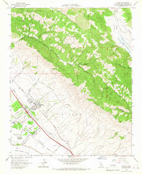
1965 Map of Nipomo
USGS Topo · Published 1967About this map
Nipomo Valley serves as a central corridor for settlement and agriculture in the mid-1960s, defined by the long stretch of Thompson Rd and the developing residential grids around Nipomo. The landscape transitions sharply from the coastal influence of Nipomo Mesa to the rugged interior uplift of Temettate Ridge. Local education is anchored by several rural campuses including Nipomo Union Sch, Dana Sch, and the more remote Huasna Sch in the northeast corner. This period shows a landscape defined by ranching and resource extraction, evidenced by the Quarry and Gravel Pit near the ridge lines. The water network is dominated by the seasonal flows of Nipomo Creek and Los Berros Creek, which have carved deep canyons through the Santa Manuela and New Som Ridge uplands, shaping the early transit routes and property boundaries like the Grant Bdy.
Find a feature on this map
44 named features on this map. Tap any name to fly to it.
Don’t see what you’re looking for? This feature index may not catch every label — zoom into the map to look around manually.
Map Details
Editions of this 1965 Nipomo Map
This is the sole edition of this map. No revisions or reprints were ever made.
Other maps of this area

1897 · Arroyo Grande
USGS Topo · 1:62,500

1900 · San Luis
USGS Topo · 1:125,000

1905 · Guadalupe
USGS Topo · 1:125,000

1905 · Lompoc
USGS Topo · 1:125,000

1922 · Nipomo
USGS Topo · 1:62,500

1942 · Guadalupe
USGS Topo · 1:125,000

1942 · Lompoc
USGS Topo · 1:125,000

1942 · Arroyo Grande
USGS Topo · 1:62,500

1942 · Santa Maria
USGS Topo · 1:62,500

1942 · Point Sal
USGS Topo · 1:62,500