1942 Map of Santa Maria
USGS Topo · Published 1942About this map
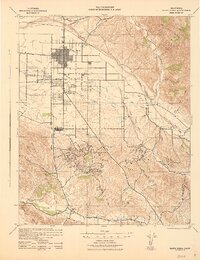
Santa Maria and its surrounding agricultural and industrial landscape are captured here during World War II, showing a region defined by the Santa Maria River and the expanding Santa Maria Valley Oil Field. The grid of the city contrasts with the winding paths of the Cuyama River and Sisquoc River to the east. Transportation is a primary theme, with the Valley Railroad threading through the valley and the early alignment of 101 connecting Suey Park to southern settlements. The terrain transitions from the alluvial plains of the Santa Maria Valley into the high elevations of the Solomon Hills, where Mt Solomon Lookout and Bicknell sit amid a complex network of canyons like Graciosa Canyon and Pine Canyon. Local civic life is evidenced by country schools such as Blochman Sch and the community grounds at Waller Grove County Park.
Find a feature on this map
45 named features on this map. Tap any name to fly to it.
Don’t see what you’re looking for? This feature index may not catch every label — zoom into the map to look around manually.
Map Details
Editions of this 1942 Santa Maria Map
This is the sole edition of this map. No revisions or reprints were ever made.
Other maps of this area

1897 · Arroyo Grande
USGS Topo · 1:62,500

1900 · San Luis
USGS Topo · 1:125,000

1905 · Guadalupe
USGS Topo · 1:125,000

1905 · Lompoc
USGS Topo · 1:125,000

1922 · Nipomo
USGS Topo · 1:62,500

1937 · Branch Mtn
USGS Topo · 1:48,000

1942 · Point Arguello
USGS Topo · 1:62,500
1942 · Guadalupe
USGS Topo · 1:125,000

1942 · Lompoc
USGS Topo · 1:125,000
1942 · Lompoc
USGS Topo · 1:62,500