
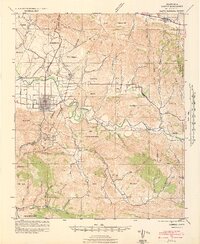
1942 Map of Lompoc
USGS Topo · Published 1942About this map
Lompoc and the surrounding Santa Barbara County coastal hills are documented here during the early years of American involvement in World War II. The landscape shows a distinct division between the grid-patterned streets of the main town along Ocean Avenue and the industrial activity at the Diatomaceous Earth Quarries to the south. This era is marked by the presence of the CCC Camp near Mission La Purisima, reflecting New Deal-era infrastructure projects that remained active or recently transitioned as the region shifted toward wartime readiness. The Santa Ynez River meanders through the center of the sheet, flanked by the Southern Pacific railroad and a network of canyons including Cebada Canyon and Purisima Canyon. Rural education centers like Maple Sch, Santa Rita Sch, and Jalama School are scattered across the valley floors, serving the ranching communities that defined the interior beyond the river banks.
Find a feature on this map
44 named features on this map. Tap any name to fly to it.
Don’t see what you’re looking for? This feature index may not catch every label — zoom into the map to look around manually.
Map Details
Editions of this 1942 Lompoc Map
2 editions found
Other maps of this area

1905 · Guadalupe
USGS Topo · 1:125,000

1905 · Lompoc
USGS Topo · 1:125,000

1942 · Point Arguello
USGS Topo · 1:62,500

1942 · Guadalupe
USGS Topo · 1:125,000

1942 · Lompoc
USGS Topo · 1:125,000

1942 · Pt. Conception
USGS Topo · 1:62,500

1942 · Santa Maria
USGS Topo · 1:62,500

1942 · Gaviota
USGS Topo · 1:62,500

1942 · Point Sal
USGS Topo · 1:62,500

1942 · Tepusquet Peak
USGS Topo · 1:62,500