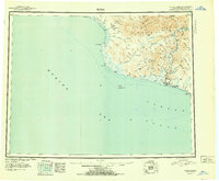
1951 Map of Nome
USGS Topo · Published 1951About this map
The Seward Peninsula Railroad snakes through the coastal terrain of the Seward Peninsula, anchoring a landscape defined by gold-era transit and mid-century military presence. Centered on the city of Nome, this post-war reconnaissance shows a region of transition where traditional travel and modern aviation meet at the local Airport. Along the coast, the Fort Davis Military Res stands near the mouth of the Nome River, while the hinterlands are dotted with markers of early 20th-century travel like the Nugget Roadhouse and various Cabin sites. The map reveals the intricate drainage patterns of the Kigluaiak Mountains, including the high peaks of Mt Osborn and the waters of Salmon L. This survey captures the logistical reality of the era, where seasonal Ferry crossings and remote Igloo locations remained vital to navigating the vast shoreline between Cape Douglas and Cape Nome.
Find a feature on this map
91 named features on this map. Tap any name to fly to it.
Don’t see what you’re looking for? This feature index may not catch every label — zoom into the map to look around manually.
Map Details
Editions of this 1951 Nome Map
2 editions found

Other maps of this area

1950 · Bendeleben A-6
USGS Topo · 1:63,360

1950 · Nome D-2
USGS Topo · 1:63,360

1950 · Nome D-4
USGS Topo · 1:63,360

1950 · Nome
USGS Topo · 1:250,000

1950 · Solomon C-6
USGS Topo · 1:63,360

1950 · Nome B-1
USGS Topo · 1:63,360

1950 · Teller
USGS Topo · 1:250,000

1950 · Bendeleben
USGS Topo · 1:250,000

1950 · Solomon B-6
USGS Topo · 1:63,360

1950 · Teller A-2
USGS Topo · 1:63,360