
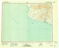
1951 Map of Nome
USGS Topo · Published 1951About this map
The coastal settlement of Nome serves as the focal point for this mid-century survey of the Seward Peninsula, where the mining-era landscape meets the Bering Sea. The map reveals the distribution of remote outposts and seasonal sites such as Jensens Camp and various cabins scattered along the drainages of the Snake River and Nome River. To the east of the townsite, the Fort Davis (Military Res) occupies a strategic position near the coast, while an Airport and multiple Landing Areas indicate the essential role of aviation in this road-sparse environment. The interior is dominated by the sharp relief of the Kigluaiak Mountains, featuring landmarks like Mt Osborn and Glacial Lake. The shoreline is marked by prominent landforms including Cape Rodney and Cape Nome, with Sledge Island positioned offshore in Norton Sound, providing a clear record of the region's geography before significant modern development.
Find a feature on this map
93 named features on this map. Tap any name to fly to it.
Don’t see what you’re looking for? This feature index may not catch every label — zoom into the map to look around manually.
Map Details
Editions of this 1951 Nome Map
2 editions found
Other maps of this area

1950 · Bendeleben A-6
USGS Topo · 1:63,360

1950 · Nome D-2
USGS Topo · 1:63,360

1950 · Nome D-4
USGS Topo · 1:63,360

1950 · Nome
USGS Topo · 1:250,000

1950 · Solomon C-6
USGS Topo · 1:63,360

1950 · Nome B-1
USGS Topo · 1:63,360

1950 · Teller
USGS Topo · 1:250,000

1950 · Bendeleben
USGS Topo · 1:250,000

1950 · Solomon B-6
USGS Topo · 1:63,360

1950 · Teller A-2
USGS Topo · 1:63,360