1950 Map of Nome D-4
USGS Topo · Published 1956About this map
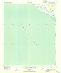
Cape Douglas marks the prominent coastal point on this 1950s map of the Seward Peninsula, where the land meets the vast expanse of the Bering Sea. The landscape is characterized by a coastal plain etched with drainage patterns like Peluk Creek and Spruce Creek, which flow toward the shoreline. A significant historical detail is the Winter Trail, shown in its approximate alignment as it traverses the terrain toward the northwest. This route represents the critical overland transport networks used during the mid-century era in Alaska, often following the most practical paths through the coastal lowlands when the ground was frozen. The map reflects a moment when photogrammetric methods were first being used to document this remote coastline, providing a record of the shoreline and hydrology before significant modern environmental changes.
Find a feature on this map
5 named features on this map. Tap any name to fly to it.
Don’t see what you’re looking for? This feature index may not catch every label — zoom into the map to look around manually.
Map Details
Editions of this 1950 Nome D-4 Map
2 editions found
Historical Maps of Unorganized Borough Through Time
591 maps found

1907 Casadepaga
Nome Borough, AK

1907 Solomon
Nome Borough, AK

1948 Norton Bay
Nome Borough, AK

1948 St Lawrence
Nome Borough, AK

1949 St Lawrence
Nome Borough, AK

1950 Bendeleben A-1
Nome Borough, AK

1950 Bendeleben A-2
Nome Borough, AK

1950 Bendeleben A-3
Nome Borough, AK

1950 Bendeleben A-4
Nome Borough, AK

1950 Bendeleben A-5
Nome Borough, AK

1950 Bendeleben A-6
Nome Borough, AK

1950 Bendeleben B-1
Nome Borough, AK

1950 Bendeleben B-2
Nome Borough, AK

1950 Bendeleben B-3
Nome Borough, AK

1950 Bendeleben B-4
Nome Borough, AK

1950 Bendeleben B-5
Nome Borough, AK

1950 Bendeleben B-6
Nome Borough, AK

1950 Bendeleben C-5
Nome Borough, AK

1950 Bendeleben C-6
Nome Borough, AK

1950 Bendeleben D-5
Nome Borough, AK

1950 Bendeleben D-6
Nome Borough, AK

1950 Bendeleben
Nome Borough, AK

1950 Candle A-5
Nome Borough, AK

1950 Candle A-6
Nome Borough, AK

1950 Candle B-5
Nome Borough, AK

1950 Candle B-6
Nome Borough, AK

1950 Kotzebue A-6
Nome Borough, AK

1950 Kotzebue B-6
Nome Borough, AK

1950 Kotzebue C-6
Nome Borough, AK

1950 Nome B-1
Nome Borough, AK

1950 Nome C-1
Nome Borough, AK

1950 Nome C-2
Nome Borough, AK

1950 Nome C-3
Nome Borough, AK

1950 Nome D-1
Nome Borough, AK

1950 Nome D-2
Nome Borough, AK

1950 Nome D-3
Nome Borough, AK

1950 Nome D-4
Nome Borough, AK

1950 Norton Bay A-3
Nome Borough, AK

1950 Norton Bay A-4
Nome Borough, AK

1950 Norton Bay B-3
Nome Borough, AK

1950 Norton Bay B-4
Nome Borough, AK

1950 Norton Bay B-5
Nome Borough, AK

1950 Norton Bay C-3
Nome Borough, AK

1950 Norton Bay C-4
Nome Borough, AK

1950 Norton Bay C-5
Nome Borough, AK

1950 Norton Bay C-6
Nome Borough, AK

1950 Norton Bay D-3
Nome Borough, AK

1950 Norton Bay D-4
Nome Borough, AK

1950 Norton Bay D-5
Nome Borough, AK

1950 Norton Bay D-6
Nome Borough, AK

1950 Shishmaref A-1
Nome Borough, AK

1950 Shishmaref A-2
Nome Borough, AK

1950 Shishmaref A-3
Nome Borough, AK

1950 Shishmaref A-4
Nome Borough, AK

1950 Shishmaref B-1
Nome Borough, AK

1950 Shishmaref B-2
Nome Borough, AK

1950 Shishmaref B-3
Nome Borough, AK

1950 Solomon B-2
Nome Borough, AK

1950 Solomon B-3
Nome Borough, AK

1950 Solomon B-6
Nome Borough, AK

1950 Solomon C-1
Nome Borough, AK

1950 Solomon C-2
Nome Borough, AK

1950 Solomon C-3
Nome Borough, AK

1950 Solomon C-4
Nome Borough, AK

1950 Solomon C-5
Nome Borough, AK

1950 Solomon C-6
Nome Borough, AK

1950 Solomon D-1
Nome Borough, AK

1950 Solomon D-2
Nome Borough, AK

1950 Solomon D-3
Nome Borough, AK

1950 Solomon D-4
Nome Borough, AK

1950 Solomon D-5
Nome Borough, AK

1950 Solomon D-6
Nome Borough, AK

1950 Solomon
Nome Borough, AK

1950 Teller A-1
Nome Borough, AK

1950 Teller A-2
Nome Borough, AK

1950 Teller A-3
Nome Borough, AK

1950 Teller A-4
Nome Borough, AK

1950 Teller B-1
Nome Borough, AK

1950 Teller B-2
Nome Borough, AK

1950 Teller B-3
Nome Borough, AK

1950 Teller B-4
Nome Borough, AK

1950 Teller B-5
Nome Borough, AK

1950 Teller B-6
Nome Borough, AK

1950 Teller C-1
Nome Borough, AK

1950 Teller C-2
Nome Borough, AK

1950 Teller C-3
Nome Borough, AK

1950 Teller C-4
Nome Borough, AK

1950 Teller C-5
Nome Borough, AK

1950 Teller C-6
Nome Borough, AK

1950 Teller C-7
Nome Borough, AK

1950 Teller D-1
Nome Borough, AK

1950 Teller D-2
Nome Borough, AK

1950 Teller D-3
Nome Borough, AK

1950 Teller D-4
Nome Borough, AK

1950 Teller D-5
Nome Borough, AK

1950 Teller D-6
Nome Borough, AK

1950 Unalakleet D-3
Nome Borough, AK

1950 Unalakleet D-4
Nome Borough, AK

1951 Bendeleben
Nome Borough, AK

1951 Norton Bay
Nome Borough, AK

1951 Solomon
Nome Borough, AK

1952 Saint Michael B-1
Nome Borough, AK

1952 Saint Michael B-2
Nome Borough, AK

1952 Saint Michael C-1
Nome Borough, AK

1952 Saint Michael C-2
Nome Borough, AK

1952 Unalakleet A-5
Nome Borough, AK

1952 Unalakleet A-6
Nome Borough, AK

1952 Unalakleet B-4
Nome Borough, AK

1952 Unalakleet B-5
Nome Borough, AK

1952 Unalakleet B-6
Nome Borough, AK

1952 Unalakleet C-4
Nome Borough, AK

1952 Unalakleet C-5
Nome Borough, AK

1952 Unalakleet D-2
Nome Borough, AK

1954 Candle A-2
Nome Borough, AK

1954 Candle B-2
Nome Borough, AK

1954 Norton Bay D-2
Nome Borough, AK

1955 Candle A-2
Nome Borough, AK

1955 Candle A-4
Nome Borough, AK

1955 Candle B-3
Nome Borough, AK

1955 Candle B-4
Nome Borough, AK

1955 Norton Bay
Nome Borough, AK

1964 Bendeleben
Nome Borough, AK

1964 St Lawrence
Nome Borough, AK

1970 Bendeleben A-4
Nome Borough, AK

1972 Nome D-1
Nome Borough, AK

1975 Nome C-3
Nome Borough, AK

2014 Bendeleben B-6 NE
Nome Borough, AK

2014 Bendeleben B-6 NW
Nome Borough, AK

2014 Bendeleben C-5 NW
Nome Borough, AK

2014 Bendeleben C-5 SW
Nome Borough, AK

2014 Bendeleben C-6 NE
Nome Borough, AK

2014 Bendeleben C-6 NW
Nome Borough, AK

2014 Bendeleben C-6 SE
Nome Borough, AK

2014 Bendeleben C-6 SW
Nome Borough, AK

2014 Bendeleben D-5 NW
Nome Borough, AK

2014 Bendeleben D-5 SW
Nome Borough, AK

2014 Bendeleben D-6 NE
Nome Borough, AK

2014 Bendeleben D-6 NW
Nome Borough, AK

2014 Bendeleben D-6 SE
Nome Borough, AK

2014 Bendeleben D-6 SW
Nome Borough, AK

2014 Candle A-3 NE
Nome Borough, AK

2014 Candle A-3 NW
Nome Borough, AK

2014 Candle A-3 SE
Nome Borough, AK

2014 Candle A-3 SW
Nome Borough, AK

2014 Candle A-4 NE
Nome Borough, AK

2014 Candle A-4 NW
Nome Borough, AK

2014 Candle A-4 SE
Nome Borough, AK

2014 Candle A-4 SW
Nome Borough, AK

2014 Candle A-5 NE
Nome Borough, AK

2014 Candle A-5 NW
Nome Borough, AK

2014 Candle A-5 SE
Nome Borough, AK

2014 Candle A-5 SW
Nome Borough, AK

2014 Candle B-2 NW
Nome Borough, AK

2014 Candle B-3 NW
Nome Borough, AK

2014 Candle B-3 SW
Nome Borough, AK

2014 Candle B-4 NE
Nome Borough, AK

2014 Candle B-4 NW
Nome Borough, AK

2014 Candle B-4 SE
Nome Borough, AK

2014 Candle B-4 SW
Nome Borough, AK

2014 Candle B-5 NE
Nome Borough, AK

2014 Candle B-5 NW
Nome Borough, AK

2014 Candle B-5 SE
Nome Borough, AK

2014 Candle B-5 SW
Nome Borough, AK

2014 Candle B-6 NE
Nome Borough, AK

2014 Kotzebue A-5 NW
Nome Borough, AK

2014 Kotzebue A-5 SW
Nome Borough, AK

2014 Kotzebue A-6 NE
Nome Borough, AK

2014 Kotzebue A-6 NW
Nome Borough, AK

2014 Kotzebue A-6 SE
Nome Borough, AK

2014 Kotzebue A-6 SW
Nome Borough, AK

2014 Kotzebue B-5 NW
Nome Borough, AK

2014 Kotzebue B-5 SW
Nome Borough, AK

2014 Kotzebue B-6 NE
Nome Borough, AK

2014 Kotzebue B-6 NW
Nome Borough, AK

2014 Kotzebue B-6 SE
Nome Borough, AK

2014 Kotzebue B-6 SW
Nome Borough, AK

2014 Kotzebue C-6 SE
Nome Borough, AK

2014 Kotzebue C-6 SW
Nome Borough, AK

2014 Norton Bay A-4 NW
Nome Borough, AK

2014 Norton Bay A-4 SW
Nome Borough, AK

2014 Norton Bay B-4 NW
Nome Borough, AK

2014 Norton Bay B-4 SW
Nome Borough, AK

2014 Norton Bay B-5 NE
Nome Borough, AK

2014 Norton Bay B-5 NW
Nome Borough, AK

2014 Norton Bay B-5 OE S NW
Nome Borough, AK

2014 Norton Bay B-5 OE S SW
Nome Borough, AK

2014 Norton Bay B-5 OE W NE
Nome Borough, AK

2014 Norton Bay B-5 SE
Nome Borough, AK

2014 Norton Bay C-4 NE
Nome Borough, AK

2014 Norton Bay C-4 NW
Nome Borough, AK

2014 Norton Bay C-4 SW
Nome Borough, AK

2014 Norton Bay C-5 SE
Nome Borough, AK

2014 Norton Bay C-5 SW
Nome Borough, AK

2014 Norton Bay C-6 NE
Nome Borough, AK

2014 Norton Bay C-6 NW
Nome Borough, AK

2014 Norton Bay D-4 NE
Nome Borough, AK

2014 Norton Bay D-4 NW
Nome Borough, AK

2014 Norton Bay D-4 SE
Nome Borough, AK

2014 Norton Bay D-4 SW
Nome Borough, AK

2014 Norton Bay D-5 NE
Nome Borough, AK

2014 Norton Bay D-5 NW
Nome Borough, AK

2014 Norton Bay D-5 SE
Nome Borough, AK

2014 Norton Bay D-5 SW
Nome Borough, AK

2014 Norton Bay D-6 NE
Nome Borough, AK

2014 Norton Bay D-6 NW
Nome Borough, AK

2014 Norton Bay D-6 SE
Nome Borough, AK

2014 Norton Bay D-6 SW
Nome Borough, AK

2014 Shishmaref A-1 NE
Nome Borough, AK

2014 Shishmaref A-1 NW
Nome Borough, AK

2014 Shishmaref A-1 SE
Nome Borough, AK

2014 Shishmaref A-1 SW
Nome Borough, AK

2014 Shishmaref A-2 NE
Nome Borough, AK

2014 Shishmaref A-2 NW
Nome Borough, AK

2014 Shishmaref A-2 SE
Nome Borough, AK

2014 Shishmaref A-2 SW
Nome Borough, AK

2014 Shishmaref A-3 NE
Nome Borough, AK

2014 Shishmaref A-3 NW
Nome Borough, AK

2014 Shishmaref A-3 SE
Nome Borough, AK

2014 Shishmaref A-3 SW
Nome Borough, AK

2014 Shishmaref A-4 NE
Nome Borough, AK

2014 Shishmaref A-4 SE
Nome Borough, AK

2014 Shishmaref A-4 SW
Nome Borough, AK

2014 Shishmaref B-1 NE
Nome Borough, AK

2014 Shishmaref B-1 NW
Nome Borough, AK

2014 Shishmaref B-1 SE
Nome Borough, AK

2014 Shishmaref B-1 SW
Nome Borough, AK

2014 Shishmaref B-2 NE
Nome Borough, AK

2014 Shishmaref B-2 SE
Nome Borough, AK

2014 Shishmaref B-2 SW
Nome Borough, AK

2014 Shishmaref B-3 SE
Nome Borough, AK

2014 Solomon B-2 NE
Nome Borough, AK

2014 Solomon B-2 NW
Nome Borough, AK

2014 Solomon B-2 SE
Nome Borough, AK

2014 Solomon B-2 SW
Nome Borough, AK

2014 Solomon B-3 NE
Nome Borough, AK

2014 Solomon B-3 NW
Nome Borough, AK

2014 Solomon B-6 NE
Nome Borough, AK

2014 Solomon C-1 NE
Nome Borough, AK

2014 Solomon C-1 NW
Nome Borough, AK

2014 Solomon C-1 SE
Nome Borough, AK

2014 Solomon C-1 SW
Nome Borough, AK

2014 Solomon C-2 NE
Nome Borough, AK

2014 Solomon C-2 NW
Nome Borough, AK

2014 Solomon C-2 SE
Nome Borough, AK

2014 Solomon C-2 SW
Nome Borough, AK

2014 Solomon C-3 SE
Nome Borough, AK

2014 Solomon D-1 NE
Nome Borough, AK

2014 Solomon D-1 NW
Nome Borough, AK

2014 Solomon D-1 SE
Nome Borough, AK

2014 Solomon D-1 SW
Nome Borough, AK

2014 Solomon D-2 NE
Nome Borough, AK

2014 Solomon D-2 SE
Nome Borough, AK

2014 Teller B-1 NE
Nome Borough, AK

2014 Teller B-1 NW
Nome Borough, AK

2014 Teller B-1 SE
Nome Borough, AK

2014 Teller B-1 SW
Nome Borough, AK

2014 Teller B-2 NE
Nome Borough, AK

2014 Teller B-2 NW
Nome Borough, AK

2014 Teller B-2 SE
Nome Borough, AK

2014 Teller B-2 SW
Nome Borough, AK

2014 Teller B-3 NE
Nome Borough, AK

2014 Teller B-3 NW
Nome Borough, AK

2014 Teller B-3 SE
Nome Borough, AK

2014 Teller B-3 SW
Nome Borough, AK

2014 Teller B-4 NE
Nome Borough, AK

2014 Teller B-4 NW
Nome Borough, AK

2014 Teller B-4 SE
Nome Borough, AK

2014 Teller B-5 NE
Nome Borough, AK

2014 Teller B-5 NW
Nome Borough, AK

2014 Teller B-6 NE
Nome Borough, AK

2014 Teller C-1 NE
Nome Borough, AK

2014 Teller C-1 NW
Nome Borough, AK

2014 Teller C-1 SE
Nome Borough, AK

2014 Teller C-1 SW
Nome Borough, AK

2014 Teller C-2 NE
Nome Borough, AK

2014 Teller C-2 NW
Nome Borough, AK

2014 Teller C-2 SE
Nome Borough, AK

2014 Teller C-2 SW
Nome Borough, AK

2014 Teller C-3 NE
Nome Borough, AK

2014 Teller C-3 NW
Nome Borough, AK

2014 Teller C-3 SE
Nome Borough, AK

2014 Teller C-3 SW
Nome Borough, AK

2014 Teller C-4 NE
Nome Borough, AK

2014 Teller C-4 NW
Nome Borough, AK

2014 Teller C-4 SE
Nome Borough, AK

2014 Teller C-4 SW
Nome Borough, AK

2014 Teller C-5 NE
Nome Borough, AK

2014 Teller C-5 NW
Nome Borough, AK

2014 Teller C-5 SE
Nome Borough, AK

2014 Teller C-5 SW
Nome Borough, AK

2014 Teller C-6 NE
Nome Borough, AK

2014 Teller C-6 NW
Nome Borough, AK

2014 Teller C-6 SE
Nome Borough, AK

2014 Teller C-6 SW
Nome Borough, AK

2014 Teller D-1 NE
Nome Borough, AK

2014 Teller D-1 NW
Nome Borough, AK

2014 Teller D-1 SE
Nome Borough, AK

2014 Teller D-1 SW
Nome Borough, AK

2014 Teller D-2 NE
Nome Borough, AK

2014 Teller D-2 NW
Nome Borough, AK

2014 Teller D-2 SE
Nome Borough, AK

2014 Teller D-2 SW
Nome Borough, AK

2014 Teller D-3 NE
Nome Borough, AK

2014 Teller D-3 NW
Nome Borough, AK

2014 Teller D-3 SE
Nome Borough, AK

2014 Teller D-3 SW
Nome Borough, AK

2014 Teller D-4 NE
Nome Borough, AK

2014 Teller D-4 NW
Nome Borough, AK

2014 Teller D-4 SE
Nome Borough, AK

2014 Teller D-4 SW
Nome Borough, AK

2014 Teller D-5 NE
Nome Borough, AK

2014 Teller D-5 NW
Nome Borough, AK

2014 Teller D-5 SE
Nome Borough, AK

2014 Teller D-5 SW
Nome Borough, AK

2014 Teller D-6 SE
Nome Borough, AK

2014 Teller D-6 SW
Nome Borough, AK

2015 Candle B-2 NE
Nome Borough, AK

2015 Candle B-2 SE
Nome Borough, AK

2015 Candle B-2 SW
Nome Borough, AK

2015 Candle B-3 SE
Nome Borough, AK

2015 Norton Bay A-3 SE
Nome Borough, AK

2015 Norton Bay A-3 SW
Nome Borough, AK

2015 Norton Bay A-4 SE
Nome Borough, AK

2015 Unalakleet C-3 NE
Nome Borough, AK

2015 Unalakleet C-3 NW
Nome Borough, AK

2015 Unalakleet C-4 NE
Nome Borough, AK

2015 Unalakleet C-4 SE
Nome Borough, AK

2015 Unalakleet D-2 NW
Nome Borough, AK

2015 Unalakleet D-2 SW
Nome Borough, AK

2015 Unalakleet D-3 NE
Nome Borough, AK

2015 Unalakleet D-3 NW
Nome Borough, AK

2015 Unalakleet D-3 SE
Nome Borough, AK

2015 Unalakleet D-3 SW
Nome Borough, AK

2015 Unalakleet D-4 NE
Nome Borough, AK

2015 Unalakleet D-4 SE
Nome Borough, AK

2016 Unalakleet A-4 NW
Nome Borough, AK

2016 Unalakleet A-4 SW
Nome Borough, AK

2016 Unalakleet B-4 NW
Nome Borough, AK

2016 Unalakleet B-4 SW
Nome Borough, AK

2016 Unalakleet C-4 NW
Nome Borough, AK

2016 Unalakleet C-4 SW
Nome Borough, AK

2016 Unalakleet D-4 NW
Nome Borough, AK

2016 Unalakleet D-4 SW
Nome Borough, AK

2017 Bendeleben A-1 NE
Nome Borough, AK

2017 Bendeleben A-1 NW
Nome Borough, AK

2017 Bendeleben A-1 SE
Nome Borough, AK

2017 Bendeleben A-1 SW
Nome Borough, AK

2017 Bendeleben A-2 NE
Nome Borough, AK

2017 Bendeleben A-2 NW
Nome Borough, AK

2017 Bendeleben A-2 SE
Nome Borough, AK

2017 Bendeleben A-2 SW
Nome Borough, AK

2017 Bendeleben A-3 NE
Nome Borough, AK

2017 Bendeleben A-3 NW
Nome Borough, AK

2017 Bendeleben A-3 SE
Nome Borough, AK

2017 Bendeleben A-3 SW
Nome Borough, AK

2017 Bendeleben A-4 NE
Nome Borough, AK

2017 Bendeleben A-4 NW
Nome Borough, AK

2017 Bendeleben A-4 SE
Nome Borough, AK

2017 Bendeleben A-4 SW
Nome Borough, AK

2017 Bendeleben A-5 NE
Nome Borough, AK

2017 Bendeleben A-5 NW
Nome Borough, AK

2017 Bendeleben A-5 SE
Nome Borough, AK

2017 Bendeleben A-5 SW
Nome Borough, AK

2017 Bendeleben A-6 NE
Nome Borough, AK

2017 Bendeleben A-6 NW
Nome Borough, AK

2017 Bendeleben A-6 SE
Nome Borough, AK

2017 Bendeleben A-6 SW
Nome Borough, AK

2017 Bendeleben B-1 NE
Nome Borough, AK

2017 Bendeleben B-1 NW
Nome Borough, AK

2017 Bendeleben B-1 SE
Nome Borough, AK

2017 Bendeleben B-1 SW
Nome Borough, AK

2017 Bendeleben B-2 NE
Nome Borough, AK

2017 Bendeleben B-2 SE
Nome Borough, AK

2017 Bendeleben B-2 SW
Nome Borough, AK

2017 Bendeleben B-3 NE
Nome Borough, AK

2017 Bendeleben B-3 SE
Nome Borough, AK

2017 Bendeleben B-3 SW
Nome Borough, AK

2017 Bendeleben B-4 NW
Nome Borough, AK

2017 Bendeleben B-4 SE
Nome Borough, AK

2017 Bendeleben B-4 SW
Nome Borough, AK

2017 Bendeleben B-5 NE
Nome Borough, AK

2017 Bendeleben B-5 NW
Nome Borough, AK

2017 Bendeleben B-5 SE
Nome Borough, AK

2017 Bendeleben B-5 SW
Nome Borough, AK

2017 Bendeleben B-6 SE
Nome Borough, AK

2017 Bendeleben B-6 SW
Nome Borough, AK

2017 Bendeleben C-4 SW
Nome Borough, AK

2017 Bendeleben C-5 NE
Nome Borough, AK

2017 Bendeleben C-5 SE
Nome Borough, AK

2017 Candle A-2 NE
Nome Borough, AK

2017 Candle A-2 NW
Nome Borough, AK

2017 Candle A-2 SE
Nome Borough, AK

2017 Candle A-2 SW
Nome Borough, AK

2017 Candle A-6 NE
Nome Borough, AK

2017 Candle A-6 NW
Nome Borough, AK

2017 Candle A-6 SE
Nome Borough, AK

2017 Candle A-6 SW
Nome Borough, AK

2017 Candle B-6 NW
Nome Borough, AK

2017 Candle B-6 SE
Nome Borough, AK

2017 Candle B-6 SW
Nome Borough, AK

2017 Nome B-1 NE
Nome Borough, AK

2017 Nome B-1 NW
Nome Borough, AK

2017 Nome C-1 NE
Nome Borough, AK

2017 Nome C-1 NW
Nome Borough, AK

2017 Nome C-1 SE
Nome Borough, AK

2017 Nome C-1 SW
Nome Borough, AK

2017 Nome C-2 NE
Nome Borough, AK

2017 Nome C-2 NW
Nome Borough, AK

2017 Nome C-2 SE
Nome Borough, AK

2017 Nome C-2 SW
Nome Borough, AK

2017 Nome C-3 NE
Nome Borough, AK

2017 Nome C-3 NW
Nome Borough, AK

2017 Nome C-3 OE S NE
Nome Borough, AK

2017 Nome C-3 SE
Nome Borough, AK

2017 Nome C-3 SW
Nome Borough, AK

2017 Nome D-1 NE
Nome Borough, AK

2017 Nome D-1 NW
Nome Borough, AK

2017 Nome D-1 SE
Nome Borough, AK

2017 Nome D-1 SW
Nome Borough, AK

2017 Nome D-2 NE
Nome Borough, AK

2017 Nome D-2 NW
Nome Borough, AK

2017 Nome D-2 SE
Nome Borough, AK

2017 Nome D-2 SW
Nome Borough, AK

2017 Nome D-3 NE
Nome Borough, AK

2017 Nome D-3 NW
Nome Borough, AK

2017 Nome D-3 SE
Nome Borough, AK

2017 Nome D-3 SW
Nome Borough, AK

2017 Nome D-4 NE
Nome Borough, AK

2017 Norton Bay A-2 SW
Nome Borough, AK

2017 Norton Bay A-3 NE
Nome Borough, AK

2017 Norton Bay A-3 NW
Nome Borough, AK

2017 Norton Bay A-4 NE
Nome Borough, AK

2017 Norton Bay B-3 NE
Nome Borough, AK

2017 Norton Bay B-3 NW
Nome Borough, AK

2017 Norton Bay B-3 SE
Nome Borough, AK

2017 Norton Bay B-3 SW
Nome Borough, AK

2017 Norton Bay B-4 NE
Nome Borough, AK

2017 Norton Bay B-4 SE
Nome Borough, AK

2017 Norton Bay C-3 NE
Nome Borough, AK

2017 Norton Bay C-3 NW
Nome Borough, AK

2017 Norton Bay C-3 SE
Nome Borough, AK

2017 Norton Bay C-3 SW
Nome Borough, AK

2017 Norton Bay C-4 SE
Nome Borough, AK

2017 Norton Bay D-2 NW
Nome Borough, AK

2017 Norton Bay D-2 SW
Nome Borough, AK

2017 Norton Bay D-3 NE
Nome Borough, AK

2017 Norton Bay D-3 NW
Nome Borough, AK

2017 Norton Bay D-3 SE
Nome Borough, AK

2017 Norton Bay D-3 SW
Nome Borough, AK

2017 Saint Michael A-1 NE
Nome Borough, AK

2017 Saint Michael B-1 NE
Nome Borough, AK

2017 Saint Michael B-1 NW
Nome Borough, AK

2017 Saint Michael B-1 SE
Nome Borough, AK

2017 Saint Michael B-1 SW
Nome Borough, AK

2017 Saint Michael B-2 SE
Nome Borough, AK

2017 Saint Michael C-1 NW
Nome Borough, AK

2017 Saint Michael C-1 SE
Nome Borough, AK

2017 Saint Michael C-1 SW
Nome Borough, AK

2017 Saint Michael C-2 NE
Nome Borough, AK

2017 Saint Michael C-2 SE
Nome Borough, AK

2017 Solomon B-6 NW
Nome Borough, AK

2017 Solomon C-3 NE
Nome Borough, AK

2017 Solomon C-3 NW
Nome Borough, AK

2017 Solomon C-4 NE
Nome Borough, AK

2017 Solomon C-4 NW
Nome Borough, AK

2017 Solomon C-5 NE
Nome Borough, AK

2017 Solomon C-5 NW
Nome Borough, AK

2017 Solomon C-6 NE
Nome Borough, AK

2017 Solomon C-6 NW
Nome Borough, AK

2017 Solomon C-6 SE
Nome Borough, AK

2017 Solomon C-6 SW
Nome Borough, AK

2017 Solomon D-2 NW
Nome Borough, AK

2017 Solomon D-2 SW
Nome Borough, AK

2017 Solomon D-3 NE
Nome Borough, AK

2017 Solomon D-3 NW
Nome Borough, AK

2017 Solomon D-3 SE
Nome Borough, AK

2017 Solomon D-3 SW
Nome Borough, AK

2017 Solomon D-4 NE
Nome Borough, AK

2017 Solomon D-4 NW
Nome Borough, AK

2017 Solomon D-4 SE
Nome Borough, AK

2017 Solomon D-4 SW
Nome Borough, AK

2017 Solomon D-5 NE
Nome Borough, AK

2017 Solomon D-5 NW
Nome Borough, AK

2017 Solomon D-5 SE
Nome Borough, AK

2017 Solomon D-5 SW
Nome Borough, AK

2017 Solomon D-6 NE
Nome Borough, AK

2017 Solomon D-6 NW
Nome Borough, AK

2017 Solomon D-6 SE
Nome Borough, AK

2017 Solomon D-6 SW
Nome Borough, AK

2017 Teller A-1 NE
Nome Borough, AK

2017 Teller A-1 NW
Nome Borough, AK

2017 Teller A-1 SE
Nome Borough, AK

2017 Teller A-1 SW
Nome Borough, AK

2017 Teller A-2 NE
Nome Borough, AK

2017 Teller A-2 NW
Nome Borough, AK

2017 Teller A-2 SE
Nome Borough, AK

2017 Teller A-2 SW
Nome Borough, AK

2017 Teller A-3 NE
Nome Borough, AK

2017 Teller A-3 NW
Nome Borough, AK

2017 Teller A-3 SE
Nome Borough, AK

2017 Teller A-3 SW
Nome Borough, AK

2017 Teller A-4 NE
Nome Borough, AK

2017 Teller A-4 NW
Nome Borough, AK

2017 Teller A-4 SE
Nome Borough, AK

2017 Teller A-4 SW
Nome Borough, AK

2017 Teller B-4 SW
Nome Borough, AK

2017 Unalakleet A-5 NE
Nome Borough, AK

2017 Unalakleet A-5 NW
Nome Borough, AK

2017 Unalakleet A-5 SE
Nome Borough, AK

2017 Unalakleet A-5 SW
Nome Borough, AK

2017 Unalakleet A-6 NE
Nome Borough, AK

2017 Unalakleet A-6 NW
Nome Borough, AK

2017 Unalakleet A-6 SE
Nome Borough, AK

2017 Unalakleet A-6 SW
Nome Borough, AK

2017 Unalakleet B-5 NE
Nome Borough, AK

2017 Unalakleet B-5 NW
Nome Borough, AK

2017 Unalakleet B-5 SE
Nome Borough, AK

2017 Unalakleet B-5 SW
Nome Borough, AK

2017 Unalakleet B-6 NE
Nome Borough, AK

2017 Unalakleet B-6 NW
Nome Borough, AK

2017 Unalakleet B-6 SE
Nome Borough, AK

2017 Unalakleet B-6 SW
Nome Borough, AK

2017 Unalakleet C-5 SE
Nome Borough, AK

2018 Solomon C-3 SW
Nome Borough, AK

2018 Solomon C-4 SE
Nome Borough, AK

2018 Solomon C-4 SW
Nome Borough, AK

2018 Solomon C-5 SE
Nome Borough, AK

2018 Solomon C-5 SW
Nome Borough, AK

2019 Bendeleben B-6 NE
Nome Borough, AK

2019 Shishmaref A-1 SE
Nome Borough, AK

2019 Teller D-3 NE
Nome Borough, AK

2019 Teller D-4 NW
Nome Borough, AK

2020 Saint Lawrence A-0 NW
Nome Borough, AK

2020 Saint Lawrence A-1 NW
Nome Borough, AK

2020 Saint Lawrence A-2 NE
Nome Borough, AK

2020 Saint Lawrence A-2 NW
Nome Borough, AK

2020 Saint Lawrence A-2 SE
Nome Borough, AK

2020 Saint Lawrence A-2 SW
Nome Borough, AK

2020 Saint Lawrence B-0 NE
Nome Borough, AK

2020 Saint Lawrence B-0 NW
Nome Borough, AK

2020 Saint Lawrence B-0 SE
Nome Borough, AK

2020 Saint Lawrence B-0 SW
Nome Borough, AK

2020 Saint Lawrence B-1 NE
Nome Borough, AK

2020 Saint Lawrence B-1 NW
Nome Borough, AK

2020 Saint Lawrence B-1 SE
Nome Borough, AK

2020 Saint Lawrence B-1 SW
Nome Borough, AK

2020 Saint Lawrence B-2 NE
Nome Borough, AK

2020 Saint Lawrence B-2 NW
Nome Borough, AK

2020 Saint Lawrence B-2 SE
Nome Borough, AK

2020 Saint Lawrence B-2 SW
Nome Borough, AK

2020 Saint Lawrence B-3 NE
Nome Borough, AK

2020 Saint Lawrence B-3 NW
Nome Borough, AK

2020 Saint Lawrence B-3 SE
Nome Borough, AK

2020 Saint Lawrence B-3 SW
Nome Borough, AK

2020 Saint Lawrence B-4 NE
Nome Borough, AK

2020 Saint Lawrence B-5 NW
Nome Borough, AK

2020 Saint Lawrence B-6 NE
Nome Borough, AK

2020 Saint Lawrence B-6 NW
Nome Borough, AK

2020 Saint Lawrence C-2 SE
Nome Borough, AK

2020 Saint Lawrence C-2 SW
Nome Borough, AK

2020 Saint Lawrence C-3 NE
Nome Borough, AK

2020 Saint Lawrence C-3 NW
Nome Borough, AK

2020 Saint Lawrence C-3 SE
Nome Borough, AK

2020 Saint Lawrence C-3 SW
Nome Borough, AK

2020 Saint Lawrence C-4 NE
Nome Borough, AK

2020 Saint Lawrence C-4 NW
Nome Borough, AK

2020 Saint Lawrence C-4 SE
Nome Borough, AK

2020 Saint Lawrence C-4 SW
Nome Borough, AK

2020 Saint Lawrence C-5 NE
Nome Borough, AK

2020 Saint Lawrence C-5 NW
Nome Borough, AK

2020 Saint Lawrence C-5 SE
Nome Borough, AK

2020 Saint Lawrence C-5 SW
Nome Borough, AK

2020 Saint Lawrence C-6 NE
Nome Borough, AK

2020 Saint Lawrence C-6 NW
Nome Borough, AK

2020 Saint Lawrence C-6 SE
Nome Borough, AK

2020 Saint Lawrence C-6 SW
Nome Borough, AK

2020 Saint Lawrence D-3 SE
Nome Borough, AK

2020 Saint Lawrence D-3 SW
Nome Borough, AK

2020 Saint Lawrence D-4 SE
Nome Borough, AK

2020 Saint Lawrence D-4 SW
Nome Borough, AK

2020 Saint Lawrence D-5 SW
Nome Borough, AK

2020 Saint Lawrence D-6 NE
Nome Borough, AK

2020 Saint Lawrence D-6 NW
Nome Borough, AK

2020 Saint Lawrence D-6 SE
Nome Borough, AK

2020 Saint Lawrence D-6 SW
Nome Borough, AK

2020 Teller C-7 NE
Nome Borough, AK

2020 Teller C-7 SE
Nome Borough, AK

2020 Teller D-8 OE S NW
Nome Borough, AK

2020 Teller D-8 SW
Nome Borough, AK

2020 Unalakleet C-5 OE W SE
Nome Borough, AK

2021 Nome D-7 NE
Nome Borough, AK