
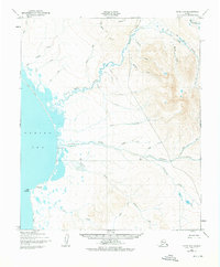
1950 Map of Nome D-3
USGS Topo · Published 1956About this map
Shea Roadhouse stands as a vital landmark along the coastline of the Bering Sea, marking a waypoint on the Winter Trail that traverses the Seward Peninsula. This 1950s survey illustrates a landscape defined by an intricate network of drainage systems, where the Tisuk River and Feather River flow westward toward the coast. The terrain is dotted with seasonal or subsistence sites like Singigyak near Cape Woolley, reflecting the sparse but essential human presence in this subarctic environment. Many of the watercourses, such as Eldorado Creek, Fairview Creek, and Livingston Creek, carry names that suggest the region's history of mineral exploration and prospecting. The presence of numerous trails and approximate alignments highlights the importance of overland travel routes through the coastal lowlands and inland ridges before the development of modern road infrastructure.
Find a feature on this map
33 named features on this map. Tap any name to fly to it.
Don’t see what you’re looking for? This feature index may not catch every label — zoom into the map to look around manually.
Map Details
Editions of this 1950 Nome D-3 Map
2 editions found
Other maps of this area

1950 · Nome D-2
USGS Topo · 1:63,360

1950 · Nome D-4
USGS Topo · 1:63,360

1950 · Nome
USGS Topo · 1:250,000

1950 · Teller
USGS Topo · 1:250,000

1950 · Teller A-2
USGS Topo · 1:63,360
1950 · Nome C-3
USGS Topo · 1:63,360

1950 · Nome C-2
USGS Topo · 1:63,360

1950 · Teller A-3
USGS Topo · 1:63,360

1950 · Teller A-4
USGS Topo · 1:63,360

1951 · Nome
USGS Topo · 1:250,000