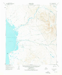
1950 Map of Nome D-3
USGS Topo · Published 1976About this map
Singigyak and Shea Roadhouse represent the modest coastal footprint of human activity on this Seward Peninsula landscape at the start of the 1950s. The coastline, anchored by the prominent Cape Woolley on the Bering Sea, gives way to an intricate drainage system where the Tisuk River and Feather River carve through the coastal plain. The map traces the vital Winter Trail as it parallels the shoreline, providing a glimpse into the seasonal transportation network used before modernized road access dominated the region.
Find a feature on this map
34 named features on this map. Tap any name to fly to it.
Don’t see what you’re looking for? This feature index may not catch every label — zoom into the map to look around manually.
Map Details
Editions of this 1950 Nome D-3 Map
2 editions found
Other maps of this area

1950 · Nome D-2
USGS Topo · 1:63,360

1950 · Nome D-4
USGS Topo · 1:63,360

1950 · Nome
USGS Topo · 1:250,000

1950 · Teller
USGS Topo · 1:250,000

1950 · Teller A-2
USGS Topo · 1:63,360
1950 · Nome C-3
USGS Topo · 1:63,360

1950 · Nome D-3
USGS Topo · 1:63,360

1950 · Nome C-2
USGS Topo · 1:63,360

1950 · Teller A-3
USGS Topo · 1:63,360

1950 · Teller A-4
USGS Topo · 1:63,360