1957 Map of Teller
USGS Topo · Published 1957About this map
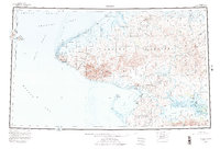
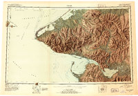
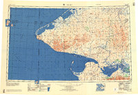
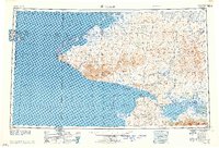
The Seward Peninsula's western tip serves as a meeting point of continents and oceans in this mid-century survey. At Cape Prince of Wales, the coastline reaches its westernmost extent, looking across the Bering Strait toward the Diomede Islands, including Ignaluk and Big Diomede Island. The U.S. Russia Convention of 1867 boundary line is clearly marked in the strait, separating American and Russian territory. On the mainland, the Wales settlement and the Teller Mission near Teller anchor the coast, while the interior is defined by the York Mountains and Kigluaik Mountains. The complex hydrology of Port Clarence, Grantley Harbor, and the Imuruk Basin creates a vast protected waterway system, connected to the hinterlands via the Agiapuk River and Kuzitrin River. Navigation along these coasts is marked by landmarks like Potato Mtna and Cassiterite Pk, reflecting a landscape defined by its maritime geography.
Find a feature on this map
53 named features on this map. Tap any name to fly to it.
Don’t see what you’re looking for? This feature index may not catch every label — zoom into the map to look around manually.
Map Details
Editions of this 1957 Teller Map
This is the sole edition of this map. No revisions or reprints were ever made.
Historical Maps of Brevig Mission Through Time
4 maps found