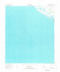
1950 Map of Nome D-4
USGS Topo · Published 1976About this map
The Bering Sea dominates this coastal survey, where the shoreline of the Seward Peninsula meets the cold northern waters at Cape Douglas. Compiled from aerial photography taken in the late 1940s, the map reveals a remote landscape defined by drainage systems and seasonal passage rather than permanent settlements. A prominent Winter Trail cuts across the tundra, providing a vital overland route between coastal points when the ground is frozen. Several small waterways, including Sourdough Creek, Spruce Creek, and Peluk Creek, meander toward the coast through low-lying terrain, illustrating the hydrologic patterns of the region before significant modern development altered the land.
Find a feature on this map
6 named features on this map. Tap any name to fly to it.
Don’t see what you’re looking for? This feature index may not catch every label — zoom into the map to look around manually.
Map Details
Editions of this 1950 Nome D-4 Map
2 editions found
Other maps of this area

1950 · Nome D-4
USGS Topo · 1:63,360

1950 · Nome
USGS Topo · 1:250,000

1950 · Teller
USGS Topo · 1:250,000
1950 · Nome C-3
USGS Topo · 1:63,360

1950 · Nome D-3
USGS Topo · 1:63,360

1950 · Teller A-3
USGS Topo · 1:63,360

1950 · Teller A-4
USGS Topo · 1:63,360

1951 · Nome
USGS Topo · 1:250,000

1951 · Teller
USGS Topo · 1:250,000

1957 · Nome
USGS Topo · 1:250,000