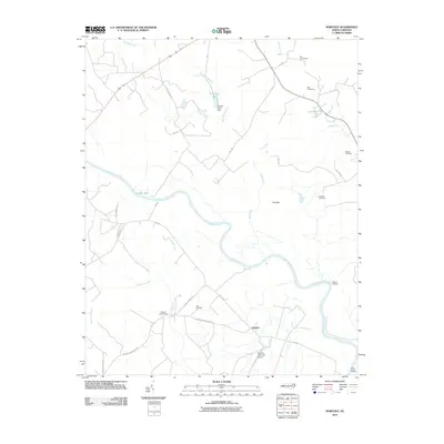
2010 Map of Norfleet
USGS Topo · Published 2010About this map
The Roanoke River snakes through this portion of eastern North Carolina, defining a landscape shaped by vast swamp systems and scattered rural settlements. Small communities like Norfleet and Fox Bark are situated among a complex network of wetlands, including Bull Neck Swamp, Cypress Swamp, and Kehukee Swamp. The infrastructure reflects a blend of traditional agricultural life and later developments, evidenced by the presence of Shields Commissary and the Ventosa Plantation Airport. Genealogists will find a high concentration of family burial sites such as the Rea Cemeteries, Bell Cemetery, and Barden Cemetery. Riverfront features like Woods Landing and George Hole indicate long-standing points of access to the water, while Turners Pond Dam shows local water management in the northern reaches of the quadrangle.
Find a feature on this map
35 named features on this map. Tap any name to fly to it.
Don’t see what you’re looking for? This feature index may not catch every label — zoom into the map to look around manually.
Map Details
Editions of this 2010 Norfleet Map
This is the sole edition of this map. No revisions or reprints were ever made.
Other maps of this area

1953 · Norfolk
USGS Topo · 1:250,000

1962 · Palmyra
USGS Topo · 1:24,000

1962 · Scotland Neck
USGS Topo · 1:24,000

1962 · Norfleet
USGS Topo · 1:24,000

1962 · Hobgood
USGS Topo · 1:24,000

1972 · Woodville
USGS Topo · 1:24,000

1973 · Kelford
USGS Topo · 1:24,000

1974 · Boones Crossroads
USGS Topo · 1:24,000

1974 · Rich Square
USGS Topo · 1:24,000

1977 · Woodland
USGS Topo · 1:24,000