
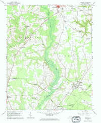
1962 Map of Hobgood
USGS Topo · Published 1964About this map
The town of Hobgood serves as a central hub on this 1962 survey, situated at the junction of two branches of the Atlantic Coast Line railroad. The surrounding landscape in this part of Halifax and Edgecombe counties is characterized by extensive wetlands, most notably the wide drainage of Deep Creek and the meandering course of Marsh Swamp. These lowlands alternate with slightly elevated agricultural areas like Roseneath and Palmyra, where a dense network of family-named landmarks and rural institutions defines the social geography.
Find a feature on this map
50 named features on this map. Tap any name to fly to it.
Don’t see what you’re looking for? This feature index may not catch every label — zoom into the map to look around manually.
Map Details
Editions of this 1962 Hobgood Map
2 editions found
Other maps of this area

1901 · Parmele
USGS Topo · 1:62,500

1902 · Parmele
USGS Topo · 1:62,500

1902 · Tarboro
USGS Topo · 1:62,500

1903 · Tarboro
USGS Topo · 1:62,500

1953 · Norfolk
USGS Topo · 1:250,000

1953 · Rocky Mount
USGS Topo · 1:250,000

1954 · Rocky Mount
USGS Topo · 1:250,000

1960 · Dawson Crossroads
USGS Topo · 1:24,000

1960 · Draughn
USGS Topo · 1:24,000

1962 · Palmyra
USGS Topo · 1:24,000