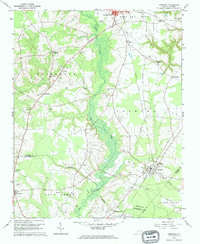
1962 Map of Hobgood
USGS Topo · Published 1964About this map
The Atlantic Coast Line railroad anchors the local economy of this Eastern North Carolina landscape, connecting the town of Hobgood and the southern edge of Scotland Neck. The terrain is defined by the broad, marshy corridor of Deep Creek and Marsh Swamp, which divide agricultural fields from wooded lowlands. Numerous family cemeteries and community churches, such as Kehukee Ch and Pleasant Hill Ch, are scattered across the rural landscape, offering significant detail for genealogists tracing regional lineages. Small community centers like Roseneath and Lawrence serve as local landmarks alongside crossroads such as Mullins Crossroads. The inclusion of specific family plots like the Leggett House Cem and educational sites like Shield Sch provides a granular view of the settlement patterns in Halifax and Edgecombe counties during the early 1960s.
Find a feature on this map
47 named features on this map. Tap any name to fly to it.
Don’t see what you’re looking for? This feature index may not catch every label — zoom into the map to look around manually.
Map Details
Editions of this 1962 Hobgood Map
2 editions found

Other maps of this area

1901 · Parmele
USGS Topo · 1:62,500

1902 · Parmele
USGS Topo · 1:62,500

1902 · Tarboro
USGS Topo · 1:62,500

1903 · Tarboro
USGS Topo · 1:62,500

1953 · Norfolk
USGS Topo · 1:250,000

1953 · Rocky Mount
USGS Topo · 1:250,000

1954 · Rocky Mount
USGS Topo · 1:250,000

1960 · Dawson Crossroads
USGS Topo · 1:24,000

1960 · Draughn
USGS Topo · 1:24,000

1962 · Palmyra
USGS Topo · 1:24,000