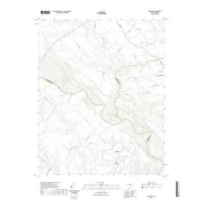
2021 Map of Norfleet
USGS Topo · Published 2021About this map
The Roanoke River snakes across this landscape, defining the jurisdictional boundaries between Bertie, Halifax, and Northampton counties. This low-lying riverine environment is characterized by extensive wetlands, including Bull Neck Swamp, Cypress Swamp, and Quinine Swamp. The settlement of Roxobel sits on higher ground at the edge of the wetlands, connected to the river basin by a network of rural routes like Norfleets Ferry Rd. Genealogy researchers can find several family-named burial sites scattered across the timbered terrain, such as the Rea Cemeteries, Bell Cem, and Barden Cem. A notable modern landmark is the Ventosa Plantation Airport, located near the riverbank. The road network, featuring names like Shields Commissary Rd and Guest House Rd, suggests a landscape shaped by long-standing agricultural estates and the timber industry typical of eastern North Carolina.
Find a feature on this map
36 named features on this map. Tap any name to fly to it.
Don’t see what you’re looking for? This feature index may not catch every label — zoom into the map to look around manually.
Map Details
Editions of this 2021 Norfleet Map
This is the sole edition of this map. No revisions or reprints were ever made.
Other maps of this area

1953 · Norfolk
USGS Topo · 1:250,000

1962 · Palmyra
USGS Topo · 1:24,000

1962 · Scotland Neck
USGS Topo · 1:24,000

1962 · Norfleet
USGS Topo · 1:24,000

1962 · Hobgood
USGS Topo · 1:24,000

1972 · Woodville
USGS Topo · 1:24,000

1973 · Kelford
USGS Topo · 1:24,000

1974 · Boones Crossroads
USGS Topo · 1:24,000

1974 · Rich Square
USGS Topo · 1:24,000

1977 · Woodland
USGS Topo · 1:24,000