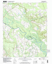
1997 Map of Norfleet
USGS Topo · Published 2000About this map
The Roanoke River dominates this landscape, winding through a dense network of wetlands where Northampton, Halifax, and Bertie counties meet. The terrain is defined by sprawling bottomlands such as Bull Neck Swamp, Quinine Swamp, and Cypress Swamp, creating a complex drainage system punctuated by family-named landmarks. The small community of Norfleet serves as a local anchor near St Stevens Ch, while the surrounding timber and agricultural lands are dotted with private burial grounds like Norfleet Cem and Hall Cem. This survey illustrates the intricate relationship between the river’s meandering path and the early settlement patterns of the region, where churches like William Chapel and Sandy Run Ch provide vital genealogical touchpoints. Notable water features, including the uniquely named Dynamite Lake and George Hole, suggest a landscape shaped by both natural flooding and local human activity.
Find a feature on this map
25 named features on this map. Tap any name to fly to it.
Don’t see what you’re looking for? This feature index may not catch every label — zoom into the map to look around manually.
Map Details
Editions of this 1997 Norfleet Map
This is the sole edition of this map. No revisions or reprints were ever made.
Other maps of this area

1953 · Norfolk
USGS Topo · 1:250,000

1962 · Palmyra
USGS Topo · 1:24,000

1962 · Scotland Neck
USGS Topo · 1:24,000

1962 · Norfleet
USGS Topo · 1:24,000

1962 · Hobgood
USGS Topo · 1:24,000

1972 · Woodville
USGS Topo · 1:24,000

1973 · Kelford
USGS Topo · 1:24,000

1974 · Boones Crossroads
USGS Topo · 1:24,000

1974 · Rich Square
USGS Topo · 1:24,000

1977 · Woodland
USGS Topo · 1:24,000