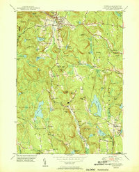
1951 Map of Norfolk
USGS Topo · Published 1951About this map
Norfolk serves as the focal point of this mid-century survey, situated at the intersection of several critical drainage basins in the Litchfield hills. The landscape is defined by its transition from high summits like Canaan Mtn and Dutton Mtn down into the narrow valleys of the Blackberry River and Mad River. This era shows a community balanced between its industrial heritage and its growing role as a recreational retreat, evidenced by the presence of the Norfolk Country Club and several state-managed lands including Algonquin State Forest and Haystack Mtn State Park. Further south, the landscape opens into the waters of Lake Winchester and North Pond, where local hamlets like North Goshen and South Norfolk anchor the rural crossroads. For genealogists, the map is particularly useful for its precise placement of numerous small burial grounds, such as Danbury Quarter Cem and the Hurlbut Cem near the Winchester Center P.O.
Find a feature on this map
77 named features on this map. Tap any name to fly to it.
Don’t see what you’re looking for? This feature index may not catch every label — zoom into the map to look around manually.
Map Details
Editions of this 1951 Norfolk Map
2 editions found
Other maps of this area

1885 · Sheffield
USGS Topo · 1:62,500

1888 · Sheffield
USGS Topo · 1:62,500

1888 · Sandisfield
USGS Topo · 1:62,500

1891 · Sheffield
USGS Topo · 1:62,500

1892 · Winsted
USGS Topo · 1:62,500

1892 · Cornwall
USGS Topo · 1:62,500

1893 · Sheffield
USGS Topo · 1:62,500

1893 · Cornwall
USGS Topo · 1:62,500

1893 · Sandisfield
USGS Topo · 1:62,500

1897 · Sandisfield
USGS Topo · 1:62,500