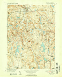
1951 Map of Norfolk
USGS Topo · Published 1951About this map
Norfolk and the surrounding Litchfield County highlands are defined by a landscape of glacial ponds and state-protected woodlands in this mid-century survey. The terrain is notably marked by public preserves such as Haystack Mtn State Park and Algonquin State Forest, indicating the region's early transition from a farm-and-mill economy toward recreation and conservation. Small clusters of rural life persist at Grantville and North Goshen, while the village of Norfolk remains the primary hub of development. Significant water bodies like Lake Winchester and Tobey Pond dominate the valleys, linked by a network of colonial-era roads like Danbury Quarter Road and Sunset Drive. The presence of numerous family-named cemeteries, including Hurlbut Cem and Danbury Quarter Cem, offers a rich resource for genealogists tracing the established lineages of the Berkshire foothills.
Find a feature on this map
79 named features on this map. Tap any name to fly to it.
Don’t see what you’re looking for? This feature index may not catch every label — zoom into the map to look around manually.
Map Details
Editions of this 1951 Norfolk Map
2 editions found
Other maps of this area

1885 · Sheffield
USGS Topo · 1:62,500

1888 · Sheffield
USGS Topo · 1:62,500

1888 · Sandisfield
USGS Topo · 1:62,500

1891 · Sheffield
USGS Topo · 1:62,500

1892 · Winsted
USGS Topo · 1:62,500

1892 · Cornwall
USGS Topo · 1:62,500

1893 · Sheffield
USGS Topo · 1:62,500

1893 · Cornwall
USGS Topo · 1:62,500

1893 · Sandisfield
USGS Topo · 1:62,500

1897 · Sandisfield
USGS Topo · 1:62,500