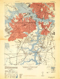
1948 Map of Norfolk South
USGS Topo · Published 1948About this map
Portsmouth and South Norfolk dominate this post-war urban landscape, where the Elizabeth River and its various branches create a complex network of industrial waterfronts and naval installations. Large tracts of the Us Naval Reservation and the US Naval Hospital at Hospital Point highlight the significant military presence that shaped the region's development during the 1940s. The map illustrates dense residential patterns in neighborhoods like Highland Park, Alexander Park, and Port Norfolk, contrasted with the southern reaches where the terrain transitions into the Dismal Swamp and the Deep Creek area.
Find a feature on this map
92 named features on this map. Tap any name to fly to it.
Don’t see what you’re looking for? This feature index may not catch every label — zoom into the map to look around manually.
Map Details
Editions of this 1948 Norfolk South Map
2 editions found
Other maps of this area

1907 · Norfolk
USGS Topo · 1:125,000

1918 · Cape Henry
USGS Topo · 1:62,500

1919 · Cape Henry
USGS Topo · 1:62,500

1921 · Newport News
USGS Topo · 1:62,500

1939 · Moyock
USGS Topo · 1:62,500

1940 · Lake Drummond
USGS Topo · 1:62,500

1944 · Norfolk South
USGS Topo · 1:25,000

1945 · Lake Drummond
USGS Topo · 1:62,500

1946 · Moyock
USGS Topo · 1:62,500

1948 · Norfolk South
USGS Topo · 1:24,000