
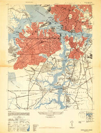
1948 Map of Norfolk South
USGS Topo · Published 1948About this map
Industrial and naval activity centers on the confluence of the Elizabeth River and its branches in the late 1940s. The urban centers of Norfolk, Portsmouth, and South Norfolk are shown in dense detail, surrounded by a complex network of rail infrastructure including the Seaboard Air Line, Atlantic Coast Line, and Virginian railroads. The map reveals the heavy military footprint of the era, from the US Naval Reservation to the specialized Degaussing Station at Lambert Point. Residential expansion is evident in planned communities like Alexander Park and Craddock, while the southern reaches of the map transition into the northern edges of the Dismal Swamp. Significant local landmarks like the US Naval Hospital and numerous cemeteries, such as Oak Grove Cemetery, provide valuable anchor points for researchers tracing the mid-century development of the Tidewater region.
Find a feature on this map
108 named features on this map. Tap any name to fly to it.
Don’t see what you’re looking for? This feature index may not catch every label — zoom into the map to look around manually.
Map Details
Editions of this 1948 Norfolk South Map
2 editions found
Other maps of this area

1907 · Norfolk
USGS Topo · 1:125,000

1918 · Cape Henry
USGS Topo · 1:62,500

1919 · Cape Henry
USGS Topo · 1:62,500

1921 · Newport News
USGS Topo · 1:62,500

1939 · Moyock
USGS Topo · 1:62,500

1940 · Lake Drummond
USGS Topo · 1:62,500

1944 · Norfolk South
USGS Topo · 1:25,000

1945 · Lake Drummond
USGS Topo · 1:62,500

1946 · Moyock
USGS Topo · 1:62,500

1948 · Ocean View
USGS Topo · 1:24,000