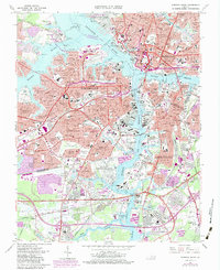
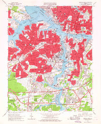
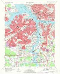
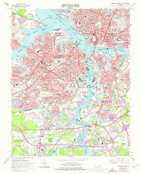
1965 Map of Norfolk South
USGS Topo · Published 1984About this map
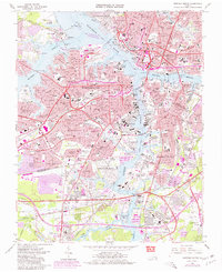
The Elizabeth River serves as the central artery for this mid-century portrait of a bustling Tidewater landscape. This 1965 survey, updated with 1980 urban data, captures the immense scale of military and maritime infrastructure, dominated by the U S Naval Shipyard, the U S Naval Hospital, and the U S Naval Ammunition Depot. The map documents a complex transport network during a period of significant growth, showing the Midtown Tunnel and Jordan Bridge connecting Portsmouth to the surrounding cities of Norfolk and Chesapeake. Notable residential developments like Cavalier Manor and Shea Terrace reflect the post-war suburban expansion. Genealogists will find a dense concentration of burial grounds, including the Lincoln Memorial Cemetery and Roosevelt Mem Park, alongside the small South Norfolk Airport and various industrial features like the Industrial Waste Ponds along the southern creek branches.
Find a feature on this map
164 named features on this map. Tap any name to fly to it.
Don’t see what you’re looking for? This feature index may not catch every label — zoom into the map to look around manually.
Map Details
Editions of this 1965 Norfolk South Map
6 editions found

Other maps of this area

1907 · Norfolk
USGS Topo · 1:125,000

1918 · Cape Henry
USGS Topo · 1:62,500

1919 · Cape Henry
USGS Topo · 1:62,500

1921 · Newport News
USGS Topo · 1:62,500

1939 · Moyock
USGS Topo · 1:62,500

1940 · Lake Drummond
USGS Topo · 1:62,500

1944 · Norfolk South
USGS Topo · 1:25,000

1945 · Lake Drummond
USGS Topo · 1:62,500

1946 · Moyock
USGS Topo · 1:62,500

1948 · Norfolk South
USGS Topo · 1:24,000