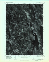
1975 Map of Norridgewock SW
USGS Topo · Published 1980About this map
Long Pond and Great Pond dominate this orthophotograph, providing a rare high-altitude perspective of the Kennebec County lakelands in the mid-1970s. Unlike traditional line-drawn maps, this aerial survey reveals the literal texture of the Maine woods and the precise density of development around Belgrade Lakes and Rome Corner. The imagery captures the transition between dense forest cover and small-scale agricultural clearings that define the rural character of Vienna and Mount Vernon. Scholars of land use can trace the historical boundaries of fields and the exact shoreline configurations of Flying Pond as they appeared before modern lakeside expansion. The contrast between the dark, water-filled basins and the surrounding timberland highlights the glacially carved nature of the terrain, offering a visual inventory of the landscape's physical state in 1975.
Find a feature on this map
7 named features on this map. Tap any name to fly to it.
Don’t see what you’re looking for? This feature index may not catch every label — zoom into the map to look around manually.
Map Details
Editions of this 1975 Norridgewock SW Map
This is the sole edition of this map. No revisions or reprints were ever made.
Other maps of this area

1892 · Augusta
USGS Topo · 1:62,500

1894 · Norridgewock
USGS Topo · 1:62,500

1898 · Norridgewock
USGS Topo · 1:62,500

1910 · Livermore
USGS Topo · 1:62,500

1912 · Livermore
USGS Topo · 1:62,500

1924 · Farmington
USGS Topo · 1:62,500

1941 · Livermore
USGS Topo · 1:62,500

1941 · Augusta
USGS Topo · 1:62,500

1943 · Augusta
USGS Topo · 1:62,500

1943 · Norridgewock
USGS Topo · 1:62,500