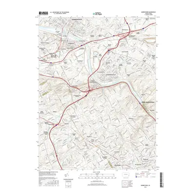
2016 Map of Norristown
USGS Topo · Published 2016About this map
The Schuylkill River corridor serves as the primary artery through this densely settled landscape, flanked by the industrial and residential hubs of Norristown, Bridgeport, and Conshohocken. Notable landmarks like Barbadoes Island and the Schuylkill River Reservoir anchor the waterway, while the surrounding hills are defined by a remarkable concentration of prestigious educational institutions. These include Villanova Univ, Bryn Mawr Coll, and Haverford College, illustrating the region's long-standing status as a center for higher learning. Genealogists will find a wealth of data across numerous burial grounds, such as Montgomery Cem, Treemount Cem, and the George Washington Memorial Park Cem. Smaller communities like Gulph Mills, Hickorytown, and Gladwyne are interconnected by a sophisticated network of roads and rail lines, including the Conshohocken Station and Radnor Station.
Find a feature on this map
119 named features on this map. Tap any name to fly to it.
Don’t see what you’re looking for? This feature index may not catch every label — zoom into the map to look around manually.
Map Details
Editions of this 2016 Norristown Map
This is the sole edition of this map. No revisions or reprints were ever made.
Other maps of this area

1891 · Philadelphia
USGS Topo · 1:62,500

1893 · Germantown
USGS Topo · 1:62,500

1894 · Chester
USGS Topo · 1:62,500

1894 · Philadelphia
USGS Topo · 1:62,500

1894 · Norristown
USGS Topo · 1:62,500

1894 · Germantown
USGS Topo · 1:62,500

1895 · Norristown
USGS Topo · 1:62,500

1896 · Germantown
USGS Topo · 1:62,500

1896 · Philadelphia
USGS Topo · 1:62,500

1896 · Norristown
USGS Topo · 1:62,500
Featured Places
- Philadelphia, PA
- Norristown, PA
- Radnor Township, PA
- King of Prussia, Upper Merion Township
- Whitemarsh Township, PA