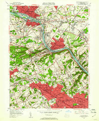
1952 Map of Norristown
USGS Topo · Published 1961About this map
The Schuylkill River carves a sharp path through this 1950s landscape, separating the industrial core of Norristown and Bridgeport from the academic and residential corridors of the Main Line. Large-scale utility and transit infrastructure is prominent, including the Pennsylvania Turnpike cutting across Plymouth and the Patco Airport situated near Black Horse. South of the river, the concentration of prestigious institutions is striking, with Villanova College, Haverford College, and Rosemont College anchoring their respective communities. The map captures a high density of rail infrastructure from the Reading and Pennsylvania lines, which served both the heavy industrial sites like Swedeland and the growing suburban centers of Ardmore and Bryn Mawr. Significant social infrastructure is also visible, from the Montgomery Hospital to the National Guard Armory, reflecting a well-established mid-century civic fabric.
Find a feature on this map
165 named features on this map. Tap any name to fly to it.
Don’t see what you’re looking for? This feature index may not catch every label — zoom into the map to look around manually.
Map Details
Editions of this 1952 Norristown Map
2 editions found
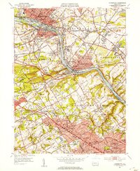
Other maps of this area

1891 · Philadelphia
USGS Topo · 1:62,500

1893 · Germantown
USGS Topo · 1:62,500

1894 · Chester
USGS Topo · 1:62,500

1894 · Philadelphia
USGS Topo · 1:62,500

1894 · Norristown
USGS Topo · 1:62,500

1894 · Germantown
USGS Topo · 1:62,500

1895 · Norristown
USGS Topo · 1:62,500

1896 · Germantown
USGS Topo · 1:62,500

1896 · Philadelphia
USGS Topo · 1:62,500

1896 · Norristown
USGS Topo · 1:62,500
Featured Places
- Philadelphia, PA
- Norristown, PA
- Radnor Township, PA
- King of Prussia, Upper Merion Township
- Whitemarsh Township, PA