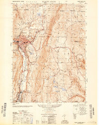
1950 Map of North Adams
USGS Topo · Published 1950About this map
The industrial corridor of the Hoosic River valley dominates this mid-century landscape, tracing the urban development of North Adams and Adams during a period of established manufacturing. The map documents the critical infrastructure of the Boston and Maine RR, most notably the Hoosac Tunnel Central Shaft, a massive engineering feat through the Hoosac Range. This mountain terrain separates the valley floor from the highland settlements of Florida and West Summit, connected by the winding path of the Mohawk Trail.
Find a feature on this map
59 named features on this map. Tap any name to fly to it.
Don’t see what you’re looking for? This feature index may not catch every label — zoom into the map to look around manually.
Map Details
Editions of this 1950 North Adams Map
This is the sole edition of this map. No revisions or reprints were ever made.
Other maps of this area

1886 · Greylock
USGS Topo · 1:62,500

1886 · Hawley
USGS Topo · 1:62,500

1889 · Wilmington
USGS Topo · 1:62,500

1890 · Hawley
USGS Topo · 1:62,500

1891 · Wilmington
USGS Topo · 1:62,500

1891 · Greylock
USGS Topo · 1:62,500

1893 · Greylock
USGS Topo · 1:62,500

1894 · Hawley
USGS Topo · 1:62,500

1898 · Bennington
USGS Topo · 1:62,500

1898 · Greylock
USGS Topo · 1:62,500