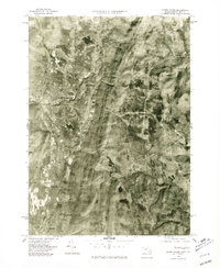
1975 Map of North Adams
USGS Topo · Published 1981About this map
The northern reaches of the Berkshires are captured in high-detail aerial photography, revealing the industrial and residential patterns of the mid-1970s. Industrial sites at Zylonite and the clustered urban center of North Adams contrast with the steep, wooded terrain of the surrounding mountains. The North Branch Hoosic River serves as the primary drainage and developmental corridor for these valley settlements, while further east, the landscape transitions into the deep folds of the Hoosac Range. This orthophoto provides a precise visual record of the region's land use just as the industrial era was shifting, showing clear distinctions between the developed valley floor and the high ground at Whitcomb Summit. Small enclaves like Briggsville appear as localized nodes of activity along the smaller waterways, including the Cold River, which carves through the eastern portion of the quadrangle toward the south.
Find a feature on this map
7 named features on this map. Tap any name to fly to it.
Don’t see what you’re looking for? This feature index may not catch every label — zoom into the map to look around manually.
Map Details
Editions of this 1975 North Adams Map
This is the sole edition of this map. No revisions or reprints were ever made.
Other maps of this area

1886 · Greylock
USGS Topo · 1:62,500

1886 · Hawley
USGS Topo · 1:62,500

1889 · Wilmington
USGS Topo · 1:62,500

1890 · Hawley
USGS Topo · 1:62,500

1891 · Wilmington
USGS Topo · 1:62,500

1891 · Greylock
USGS Topo · 1:62,500

1893 · Greylock
USGS Topo · 1:62,500

1894 · Hawley
USGS Topo · 1:62,500

1898 · Bennington
USGS Topo · 1:62,500

1898 · Greylock
USGS Topo · 1:62,500