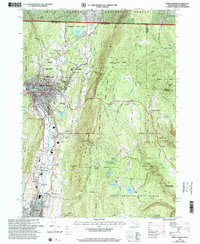
1997 Map of North Adams
USGS Topo · Published 2000About this map
The Hoosic River valley serves as the industrial and social spine of this Northern Berkshire landscape, where the city of North Adams sits at the junction of significant transport corridors. The Boston and Maine RR winds through the urban center, reflecting the area's history of manufacturing and rail connectivity that built settlements like Zylonite, Renfrew, and Houghtonville. This late 20th-century revision captures the educational and civic infrastructure of the period, including the Drury High Sch and McCann Technical Sch, alongside older landmarks like the Armory and City Hall.
Find a feature on this map
111 named features on this map. Tap any name to fly to it.
Don’t see what you’re looking for? This feature index may not catch every label — zoom into the map to look around manually.
Map Details
Editions of this 1997 North Adams Map
This is the sole edition of this map. No revisions or reprints were ever made.
Other maps of this area

1886 · Greylock
USGS Topo · 1:62,500

1886 · Hawley
USGS Topo · 1:62,500

1889 · Wilmington
USGS Topo · 1:62,500

1890 · Hawley
USGS Topo · 1:62,500

1891 · Wilmington
USGS Topo · 1:62,500

1891 · Greylock
USGS Topo · 1:62,500

1893 · Greylock
USGS Topo · 1:62,500

1894 · Hawley
USGS Topo · 1:62,500

1898 · Bennington
USGS Topo · 1:62,500

1898 · Greylock
USGS Topo · 1:62,500