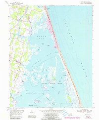
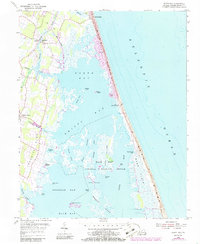
1953 Map of North Bay
USGS Topo · Published 1990About this map
Sandbridge Beach and the narrow barrier peninsula of Sandridge separate the marshy waters of the Virginia coast from the Atlantic Ocean. This landscape is defined by the transition from the upland communities of Sigma and Dawley Corners to the expansive wetlands of the Back Bay National Wildlife Refuge. The map reveals a complex system of waterways, including North Bay, Shipp s Bay, and Redhead Bay, which are punctuated by distinctive landforms like Charity Neck and Long Island. Significant coastal infrastructure is present, notably the Little Island Coast Guard Station and several Observation Towers along the shoreline. Local genealogy and history are anchored by the Tabernacle Ch and various Cem locations, while names like Rock Island Haul and Hill Landing speak to the area's traditional maritime and bay-front heritage.
Find a feature on this map
44 named features on this map. Tap any name to fly to it.
Don’t see what you’re looking for? This feature index may not catch every label — zoom into the map to look around manually.
Map Details
Editions of this 1953 North Bay Map
5 editions found
Other maps of this area

1893 · Virginia Beach
USGS Topo · 1:125,000

1907 · Norfolk
USGS Topo · 1:125,000

1916 · Back Bay
USGS Topo · 1:62,500

1918 · Cape Henry
USGS Topo · 1:62,500

1919 · Cape Henry
USGS Topo · 1:62,500

1939 · Moyock
USGS Topo · 1:62,500

1943 · Back Bay
USGS Topo · 1:62,500

1946 · Moyock
USGS Topo · 1:62,500

1946 · Eastville
USGS Topo · 1:250,000

1946 · Currituck Sound
USGS Topo · 1:250,000