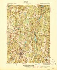
1946 Map of North Brookfield
USGS Topo · Published 1946About this map
North Brookfield and the surrounding Worcester County highlands are depicted here at the close of the Second World War, showing a landscape defined by industrial villages and numerous glacial ponds. The settlement pattern reveals the core of North Brookfield as a dense center of activity, supported by the Boston and Albany RR and marked by civic landmarks like the North Brookfield High School and Walnut Grove Cem.
Find a feature on this map
43 named features on this map. Tap any name to fly to it.
Don’t see what you’re looking for? This feature index may not catch every label — zoom into the map to look around manually.
Map Details
Editions of this 1946 North Brookfield Map
2 editions found
Other maps of this area

1885 · Worcester
USGS Topo · 1:62,500

1886 · Worcester
USGS Topo · 1:62,500

1887 · Brookfield
USGS Topo · 1:62,500

1887 · Barre
USGS Topo · 1:62,500

1889 · Webster
USGS Topo · 1:62,500

1889 · Barre
USGS Topo · 1:62,500

1890 · Brookfield
USGS Topo · 1:62,500

1892 · Webster
USGS Topo · 1:62,500

1892 · Worcester
USGS Topo · 1:62,500

1893 · Brookfield
USGS Topo · 1:62,500