
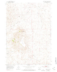
1953 Map of North Butte
USGS Topo · Published 1954About this map
The Pumpkin Buttes rise prominently above the Wyoming plains in this mid-century topographic survey, produced in cooperation with the Atomic Energy Commission. This specific interest from the Commission points to the era's focus on uranium exploration within the Powder River Basin. The high plateau of North Butte and the adjacent Dome Butte dominate the central landscape, surrounded by a network of drainage systems including Willow Creek, Hartzog Draw, and South Prong Pumpkin Creek.
Find a feature on this map
16 named features on this map. Tap any name to fly to it.
Don’t see what you’re looking for? This feature index may not catch every label — zoom into the map to look around manually.
Map Details
Editions of this 1953 North Butte Map
2 editions found
Other maps of this area

1953 · Dry Fork Ranch
USGS Topo · 1:24,000

1953 · Fort Reno SE
USGS Topo · 1:24,000

1953 · Savageton
USGS Topo · 1:24,000

1953 · Fats Draw
USGS Topo · 1:24,000

1953 · South Butte
USGS Topo · 1:24,000

1953 · The Nipple
USGS Topo · 1:24,000

1953 · Rolling Pin Ranch
USGS Topo · 1:24,000

1955 · Newcastle
USGS Topo · 1:250,000

1955 · Arminto
USGS Topo · 1:250,000

1958 · Arminto
USGS Topo · 1:250,000