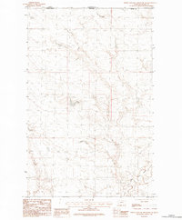
1984 Map of North Chinook Reservoir NE
USGS Topo · Published 1984About this map
The international border between the United States and Canada defines the northern edge of this northern Montana landscape, where the plains of Blaine Co meet Saskatchewan. The terrain is characterized by the winding path of East Fork Battle Creek as it meanders through the southeast corner, providing a vital water source in an otherwise high-prairie environment. This 1984 provisional edition highlights the sparse human footprint of the era, focusing instead on the intricate topography of the northern plains and the geometric precision of the border line between Montana and its Canadian neighbor. The map offers a clear view of the drainage patterns and land elevations that dictated ranching and movement along the borderlands during the late 20th century.
Find a feature on this map
4 named features on this map. Tap any name to fly to it.
Don’t see what you’re looking for? This feature index may not catch every label — zoom into the map to look around manually.
Map Details
Editions of this 1984 North Chinook Reservoir NE Map
This is the sole edition of this map. No revisions or reprints were ever made.
Other maps of this area

1912 · Zurich
USGS Topo · 1:125,000

1953 · Havre
USGS Topo · 1:250,000

1957 · Havre
USGS Topo · 1:250,000

1958 · Havre
USGS Topo · 1:250,000
1984 · Richmond Reservoir SW
USGS Topo · 1:24,000
1984 · Mc Laren Reservoir
USGS Topo · 1:24,000

1984 · Havre
USGS Topo · 1:100,000
1984 · Richmond Reservoir NW
USGS Topo · 1:24,000
1984 · North Chinook Reservoir
USGS Topo · 1:24,000
1984 · North Chinook Reservoir NW
USGS Topo · 1:24,000