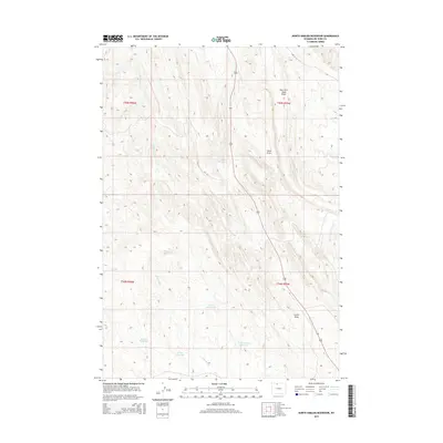
2015 Map of North Emblem Reservoir
USGS Topo · Published 2015About this map
The arid drainage patterns of Big Horn County define this 2015 landscape, where human activity is marked by a network of catchments and draws. Irrigation and water management are the primary drivers of the area's layout, evidenced by the numerous small reservoirs including Cleopatra Reservoir, Jolly Reservoir, and Caesar Reservoir. These features, alongside Rolston Reservoir and Karate Reservoir, indicate a sophisticated system of water storage used to support the high desert environment.
Find a feature on this map
16 named features on this map. Tap any name to fly to it.
Don’t see what you’re looking for? This feature index may not catch every label — zoom into the map to look around manually.
Map Details
Editions of this 2015 North Emblem Reservoir Map
This is the sole edition of this map. No revisions or reprints were ever made.
Other maps of this area

1955 · Cody
USGS Topo · 1:250,000

1958 · Cody
USGS Topo · 1:250,000

1962 · Cody
USGS Topo · 1:250,000

1964 · Kane
USGS Topo · 1:24,000

1964 · Lovell Lakes
USGS Topo · 1:24,000
1966 · Sheep Canyon
USGS Topo · 1:24,000

1966 · North Emblem Reservoir
USGS Topo · 1:24,000

1966 · Jack Horner Reservoir
USGS Topo · 1:24,000

1966 · Emblem SE
USGS Topo · 1:24,000
1966 · Lovell
USGS Topo · 1:24,000