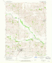
1968 Map of North English
USGS Topo · Published 1970About this map
North English River and its various tributaries, including Middle English Creek and Gritter Creek, carve through the rolling agricultural landscape of eastern Iowa during the late 1960s. The town of North English sits at the southern edge of the sheet, straddling the Iowa Co Keokuk Co line. This survey provides a clear view of the rural infrastructure of the era, from the Chicago Milwaukee St Paul and Pacific railroad line passing through Parnell to the network of section-line roads connecting outlying farmsteads. Local history is anchored by several burial grounds and community landmarks, such as Campbell Cem, Yankee Point Cem, and Pleasant Grove Ch. The presence of a High Sch and Golf Course in North English highlights the town's role as a local center for education and recreation in a region defined by its fertile river valleys and upland prairie.
Find a feature on this map
21 named features on this map. Tap any name to fly to it.
Don’t see what you’re looking for? This feature index may not catch every label — zoom into the map to look around manually.
Map Details
Editions of this 1968 North English Map
This is the sole edition of this map. No revisions or reprints were ever made.
Other maps of this area

1891 · Oxford
USGS Topo · 1:62,500

1894 · Oxford
USGS Topo · 1:62,500

1903 · Fairfax
USGS Topo · 1:125,000

1954 · Des Moines
USGS Topo · 1:250,000

1956 · Des Moines
USGS Topo · 1:250,000

1957 · Des Moines
USGS Topo · 1:250,000

1958 · Davenport
USGS Topo · 1:250,000

1961 · Davenport
USGS Topo · 1:250,000

1962 · Davenport
USGS Topo · 1:250,000

1965 · Keswick
USGS Topo · 1:24,000