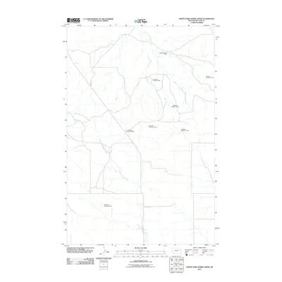
2011 Map of North Fork Horse Creek
USGS Topo · Published 2011About this map
The North Fork Horse Creek watershed dominates this corner of McCone County, Montana, where a complex network of small-scale water management infrastructure defines the drainage basins. The landscape is characterized by numerous local reservoirs, including a significant series of dams named for the Breitbach family, such as Breitbach Number 1 Dam and Breitbach Number 6 Dam. These structures, alongside the Gibbs Number 1 Dam, suggest a ranching or agricultural economy dependent on capturing seasonal runoff in a region where water is a critical resource.
Find a feature on this map
14 named features on this map. Tap any name to fly to it.
Don’t see what you’re looking for? This feature index may not catch every label — zoom into the map to look around manually.
Map Details
Editions of this 2011 North Fork Horse Creek Map
This is the sole edition of this map. No revisions or reprints were ever made.
Other maps of this area

1954 · Glendive
USGS Topo · 1:250,000

1957 · Glendive
USGS Topo · 1:250,000

1958 · Glendive
USGS Topo · 1:250,000

1982 · Circle
USGS Topo · 1:100,000

1983 · Youngquist Mine
USGS Topo · 1:24,000
1983 · Figure Eight Creek
USGS Topo · 1:24,000

1983 · Brockway NE
USGS Topo · 1:24,000

1983 · Haynie Reservoir
USGS Topo · 1:24,000

1983 · Pedigo Coulee
USGS Topo · 1:24,000

1983 · North Fork Horse Creek
USGS Topo · 1:24,000