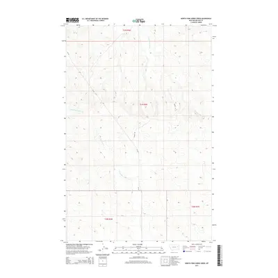
2014 Map of North Fork Horse Creek
USGS Topo · Published 2014About this map
N Fork Horse Cr and its many intermittent tributaries carve a complex drainage pattern across this high plains landscape in eastern Montana. This 2014 survey documents the remote terrain of McCone County, where the topography is defined by the divides between Middle Fork McGuire Cr and E Fork Prairie Elk Cr. The map provides a precise look at the township and range system, specifically covering sections of t22n r46e, t21n r46e, and t20n r46e. While the area remains largely undeveloped, the presence of MT-252 and Dinger Rd indicate the vital road network connecting isolated ranchlands. For the researcher, the map captures the exact contour of the draws and ridges that have shaped land use and property boundaries in this part of the Big Sky state for generations.
Find a feature on this map
9 named features on this map. Tap any name to fly to it.
Don’t see what you’re looking for? This feature index may not catch every label — zoom into the map to look around manually.
Map Details
Editions of this 2014 North Fork Horse Creek Map
This is the sole edition of this map. No revisions or reprints were ever made.
Other maps of this area

1954 · Glendive
USGS Topo · 1:250,000

1957 · Glendive
USGS Topo · 1:250,000

1958 · Glendive
USGS Topo · 1:250,000

1982 · Circle
USGS Topo · 1:100,000

1983 · Youngquist Mine
USGS Topo · 1:24,000
1983 · Figure Eight Creek
USGS Topo · 1:24,000

1983 · Brockway NE
USGS Topo · 1:24,000

1983 · Haynie Reservoir
USGS Topo · 1:24,000

1983 · Pedigo Coulee
USGS Topo · 1:24,000

1983 · North Fork Horse Creek
USGS Topo · 1:24,000