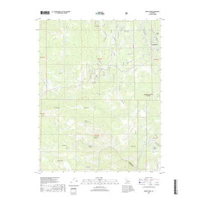
2018 Map of North Fork
USGS Topo · Published 2018About this map
The San Joaquin River carves the southern boundary of this landscape, marking the topographic divide between Madera and Fresno counties. As the foothills rise into the Sierra National Forest, the settlement of North Fork serves as a central hub for the surrounding ridges and canyons. The area is defined by its complex drainage network, where Fine Gold Creek and its various forks feed into the higher country. Evidence of the region's long-standing community and land use is found in sites like the North Fork Cemetery and the more isolated Walker Cemetery to the west. Distinctive geological formations such as Kennedy Table, Bug Table, and the volcanic-sounding Table Mountain Field stand out against the high peaks of Smiley Mountain and Fish Creek Mountain. The transition from river valley to high sierra is further illustrated by the presence of the Manzanita Flume Line and infrastructure like the Bass Lake RS Heliport.
Find a feature on this map
70 named features on this map. Tap any name to fly to it.
Don’t see what you’re looking for? This feature index may not catch every label — zoom into the map to look around manually.
Map Details
Editions of this 2018 North Fork Map
This is the sole edition of this map. No revisions or reprints were ever made.
Other maps of this area

1904 · Kaiser
USGS Topo · 1:125,000

1912 · Mariposa
USGS Topo · 1:125,000

1916 · Sulphur Springs
USGS Topo · 1:24,000

1919 · Sulphur Springs
USGS Topo · 1:31,680

1942 · Millerton Lake
USGS Topo · 1:62,500

1945 · Millerton Lake
USGS Topo · 1:62,500

1947 · Mariposa
USGS Topo · 1:250,000

1948 · Mariposa
USGS Topo · 1:250,000
1953 · Bass Lake
USGS Topo · 1:62,500

1953 · Shaver Lake
USGS Topo · 1:62,500