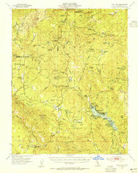
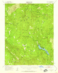
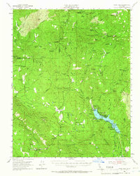
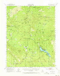
1953 Map of Bass Lake
USGS Topo · Published 1955About this map
Bass Lake and its surrounding mountain communities anchor this mid-century survey of the southern Sierra Nevada. The map documents the area during a period of transition, where recreational destinations like The Pines and The Falls coexist with long-standing resource-extraction sites such as the Enterprise Mine and Texas Flat Mine. The complex topography is marked by significant stands of giants, including the Mariposa Grove and Nelder Grove, while the local social fabric is revealed through the placement of the Nipinnawassee Sch and the Ahwahnee Sanatorium. Settlements like Oakhurst and Coarsegold serve as valley gateways to the higher elevations of Yosemite National Park. Notable family landmarks, including Bissetts Ranch and Teaford Ranch, are noted alongside earlier historical footprints such as the China Wells site, providing a detailed record of land use and habitation in the foothills.
Find a feature on this map
111 named features on this map. Tap any name to fly to it.
Don’t see what you’re looking for? This feature index may not catch every label — zoom into the map to look around manually.
Map Details
Editions of this 1953 Bass Lake Map
4 editions found
Other maps of this area

1897 · Yosemite
USGS Topo · 1:125,000

1900 · Yosemite
USGS Topo · 1:125,000

1901 · Mt. Lyell
USGS Topo · 1:125,000

1903 · Yosemite
USGS Topo · 1:125,000

1904 · Kaiser
USGS Topo · 1:125,000

1909 · Yosemite
USGS Topo · 1:125,000

1912 · Mariposa
USGS Topo · 1:125,000

1942 · Raymond
USGS Topo · 1:62,500

1942 · Millerton Lake
USGS Topo · 1:62,500

1944 · Raymond
USGS Topo · 1:62,500